
Thank you for supporting this site ❤️
Make a donation
Make a donation
Luxborough topographic map
Click on the map to display elevation.
Thank you for supporting this site ❤️
Make a donation
Make a donation
About this map
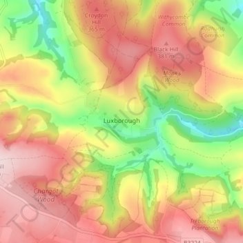
Name: Luxborough topographic map, elevation, terrain.
Average elevation: 292 m
Minimum elevation: 135 m
Maximum elevation: 418 m
Thank you for supporting this site ❤️
Make a donation
Make a donation
Other topographic maps
Click on a map to view its topography, its elevation and its terrain.
Halse Combe
United Kingdom > England > Somerset > Somerset West and Taunton > Allerford > Horner
Average elevation: 134 m
Allerford
United Kingdom > England > Somerset > Somerset West and Taunton > Allerford
Average elevation: 112 m
Horner Water
United Kingdom > England > Somerset > Somerset West and Taunton > Luccombe
Average elevation: 248 m
Bossington
United Kingdom > England > Somerset > Somerset West and Taunton > Bossington
Average elevation: 69 m
Thank you for supporting this site ❤️
Make a donation
Make a donation