
Thank you for supporting this site ❤️
Make a donation
Make a donation
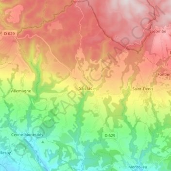
Saissac topographic map
Click on the map to display elevation.
Thank you for supporting this site ❤️
Make a donation
Make a donation
Saissac
The village is perched in the foothills of the Montagne Noire (Black Mountain) at an altitude of 467 m and has views of the Vernassonne Gorge as well as the valley plain which stretches between Carcassonne and Castelnaudary.
Thank you for supporting this site ❤️
Make a donation
Make a donation
About this map
Name: Saissac topographic map, elevation, terrain.
Average elevation: 473 m
Minimum elevation: 151 m
Maximum elevation: 852 m
Thank you for supporting this site ❤️
Make a donation
Make a donation
Other topographic maps
Click on a map to view its topography, its elevation and its terrain.