
Make a donation
Honolulu topographic map
Click on the map to display elevation.
Make a donation
About this map
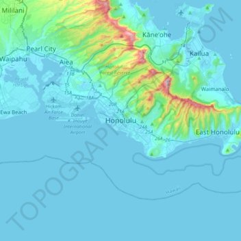
Name: Honolulu topographic map, elevation, terrain.
Location: Honolulu, Honolulu County, Hawaii, 96813, United States (21.14455 -158.01568 21.46455 -157.69568)
Average elevation: 71 m
Minimum elevation: -2 m
Maximum elevation: 928 m
Make a donation
Other topographic maps
Click on a map to view its topography, its elevation and its terrain.
Schofield Barracks
United States > Hawaii > Honolulu County > Waipahu
Schofield Barracks has a tropical savanna climate. Owing to a higher elevation, Schofield is slightly cooler year round than Honolulu, but is still well within the realms of a tropical climate. Precipitation patterns closely resemble those of mediterranean climates being found in mainland California, but its…
Average elevation: 279 m
Make a donation
Make a donation
Marine Corps Base Hawaii Kaneohe
United States > Hawaii > Honolulu County > Kaneohe
Average elevation: 7 m
Make a donation
Whitmore Village
United States > Hawaii > Honolulu County > Wahiawā > Whitmore Village
Average elevation: 298 m
Make a donation
Hawaii Kai Ridge & Cove
United States > Hawaii > Honolulu County > East Honolulu
Average elevation: 123 m
Make a donation
Ho'omaluhia Botanical Garden
United States > Hawaii > Honolulu County > Kaneohe > Keapuka
Average elevation: 155 m
Joint Base Pearl Harbor-Hickam
United States > Hawaii > Honolulu County > Waipahu
Average elevation: 7 m
Make a donation
Maili
United States > Hawaii > Honolulu County > Kapolei
Māʻili (Hawaiian pronunciation: [maːˈʔili]) is a census-designated place (CDP) in the Waiʻanae District on the island of Oʻahu, City & County of Honolulu, Hawaiʻi, United States. In Hawaiian, māʻili means "pebbly", referring to rounded stones at the shore. Māʻili is located along Farrington Highway…
Average elevation: 6 m
Make a donation
Make a donation
Oʻahu Forest National Wildlife Refuge
United States > Hawaii > Honolulu County > Mililani
Average elevation: 456 m
Make a donation