
Bezirk Oberklettgau topographic map
Interactive map
Click on the map to display elevation.
About this map
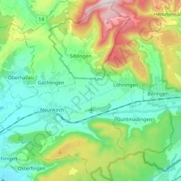
Name: Bezirk Oberklettgau topographic map, elevation, terrain.
Location: Bezirk Oberklettgau, Schaffhouse, Suisse (47.65685 8.46283 47.74104 8.56633)
Average elevation: 544 m
Minimum elevation: 396 m
Maximum elevation: 900 m
Other topographic maps
Click on a map to view its topography, its elevation and its terrain.
Neuhausen am Rheinfall
Neuhausen am Rheinfall, Schaffhouse, 8212, Suisse
Average elevation: 450 m
Neunkirch
Suisse > Schaffhouse > Bezirk Oberklettgau
Neunkirch, Bezirk Oberklettgau, Schaffhouse, 8213, Suisse
Average elevation: 487 m
Bezirk Unterklettgau
Bezirk Unterklettgau, Schaffhouse, Suisse
Average elevation: 487 m
Trasadingen
Suisse > Schaffhouse > Bezirk Unterklettgau
Trasadingen, Bezirk Unterklettgau, Schaffhouse, 8219, Suisse
Average elevation: 444 m