
Stein am Rhein topographic map
Interactive map
Click on the map to display elevation.
About this map
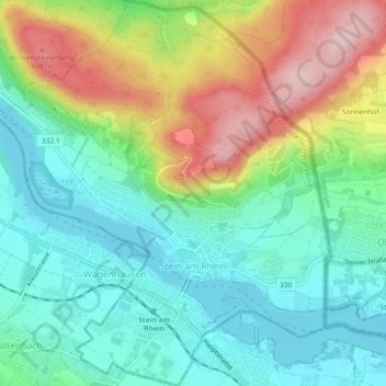
Name: Stein am Rhein topographic map, elevation, terrain.
Location: Stein am Rhein, Schaffhouse, 8260, Suisse (47.65008 8.83684 47.68103 8.87615)
Average elevation: 474 m
Minimum elevation: 390 m
Maximum elevation: 636 m
Commune réputée pour sa vieille ville datant du Moyen Âge, elle se situe à l’endroit où l’Untersee débouche dans le Rhin, à 413 mètres d’altitude. Son territoire se repartit sur les deux côtés du fleuve. Elle est un centre de transit connu entre la Suisse et l'Allemagne.
Other topographic maps
Click on a map to view its topography, its elevation and its terrain.
Neuhausen am Rheinfall
Neuhausen am Rheinfall, Schaffhouse, 8212, Suisse
Average elevation: 450 m
Neunkirch
Suisse > Schaffhouse > Bezirk Oberklettgau
Neunkirch, Bezirk Oberklettgau, Schaffhouse, 8213, Suisse
Average elevation: 487 m
Bezirk Unterklettgau
Bezirk Unterklettgau, Schaffhouse, Suisse
Average elevation: 487 m
Bezirk Oberklettgau
Bezirk Oberklettgau, Schaffhouse, Suisse
Average elevation: 544 m
Trasadingen
Suisse > Schaffhouse > Bezirk Unterklettgau
Trasadingen, Bezirk Unterklettgau, Schaffhouse, 8219, Suisse
Average elevation: 444 m