
Make a donation
Lake County topographic map
Click on the map to display elevation.
Make a donation
Lake County
Ridges on the Lake Plain physiographic region, and on which some roads are laid, are beaches formed by the various glacial lakes which occurred as the glaciers receded. Lake Maumee was the highest glacial lake at about 760 feet, and left Maumee II beach. Whittlesey beach, formed by Lake Whittlesey at 740 feet, is known as South Ridge. Arkona beach (Lake Arkona) is Middle Ridge, and occurs at about 690 feet. North Ridge is the remnant of Warren beach (Lake Warren), at an elevation of 685 feet. Elkton beach is the northernmost ridge, at 625 feet, an occurred at the time of Lake Elkton. Lake Shore Boulevard follows Elkton beach in Mentor Township.
Make a donation
About this map
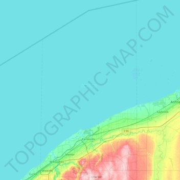
Name: Lake County topographic map, elevation, terrain.
Location: Lake County, Ohio, United States (41.56967 -81.48869 42.24595 -81.00258)
Average elevation: 196 m
Minimum elevation: 170 m
Maximum elevation: 411 m
Make a donation
Other topographic maps
Click on a map to view its topography, its elevation and its terrain.
Make a donation
Make a donation
Make a donation
Make a donation
Make a donation
Cleveland
United States > Ohio > Cuyahoga County > Cleveland
The land rises quickly from the lake shore elevation of 569 feet. Public Square, less than one mile (1.6 km) inland, sits at an elevation of 650 feet (198 m), and Hopkins Airport, 5 miles (8 km) inland from the lake, is at an elevation of 791 feet (241 m).
Average elevation: 221 m
Make a donation
Cedar Creek Woods
United States > Ohio > Wood County > Northwood > Cedar Creek Woods
Average elevation: 185 m
Make a donation
Mansfield
United States > Ohio > Richland County > Mansfield > Mansfield
Mansfield is located at 40°45′17″N 82°31′22″W / 40.75472°N 82.52278°W / 40.75472; -82.52278 (40.754856, −82.522855), directly between Columbus and Cleveland, however, the city lies in the western foothills of the Allegheny Plateau, and its elevation is among the highest of Ohio cities.…
Average elevation: 371 m
Make a donation
Pine Lake Estates
United States > Ohio > Fairfield County > Pine Lake Estates
Average elevation: 298 m
Make a donation