
Thank you for supporting this site ❤️
Make a donation
Make a donation
Springdale topographic map
Click on the map to display elevation.
Thank you for supporting this site ❤️
Make a donation
Make a donation
About this map
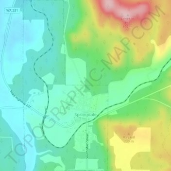
Name: Springdale topographic map, elevation, terrain.
Location: Springdale, Stevens County, Washington, United States (48.04844 -117.75785 48.07768 -117.73607)
Average elevation: 656 m
Minimum elevation: 582 m
Maximum elevation: 818 m
Thank you for supporting this site ❤️
Make a donation
Make a donation
Other topographic maps
Click on a map to view its topography, its elevation and its terrain.
Thank you for supporting this site ❤️
Make a donation
Make a donation
Thank you for supporting this site ❤️
Make a donation
Make a donation
Ford
United States > Washington > Stevens County
Ford is located in a mountainous area at the base of Happy Hill, which rises more than 600 feet immediately to the southeast of the community. The northeast–southwest trending Walkers Prairie and valley floor along which Chamokane Creek flows is relatively flat and at an elevation of between 1,700 and 1,800…
Average elevation: 577 m
Thank you for supporting this site ❤️
Make a donation
Make a donation