
Thank you for supporting this site ❤️
Make a donation
Make a donation
Darab Island topographic map
Click on the map to display elevation.
Thank you for supporting this site ❤️
Make a donation
Make a donation
About this map
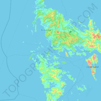
Name: Darab Island topographic map, elevation, terrain.
Location: Darab Island, Culion, Palawan, Mimaropa, Philippines (11.68000 119.64667 12.32000 120.28667)
Average elevation: 26 m
Minimum elevation: -1 m
Maximum elevation: 590 m
Thank you for supporting this site ❤️
Make a donation
Make a donation
Other topographic maps
Click on a map to view its topography, its elevation and its terrain.