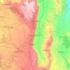
Western topographic map
Click on the map to display elevation.
About this map
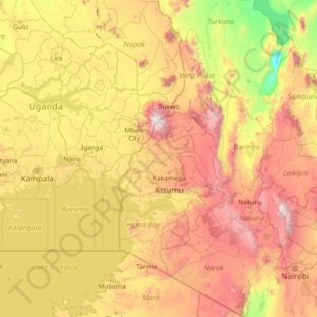
Name: Western topographic map, elevation, terrain.
Location: Western, Kenya (-2.09096 31.97313 3.10904 37.17313)
Average elevation: 1,322 m
Minimum elevation: 276 m
Maximum elevation: 4,166 m
Other topographic maps
Click on a map to view its topography, its elevation and its terrain.
Nairobi
Nairobi was founded in 1899 by colonial authorities in British East Africa, as a rail depot on the Uganda - Kenya Railway. It was favoured by the authorities as an ideal resting place due to its high elevation, temperate climate, and adequate water supply. The town quickly grew to replace Mombasa as the…
Average elevation: 1,729 m


Mombasa
Being a coastal town, Mombasa is characterised by a flat topography. The town of Mombasa is centred on Mombasa Island, but extends to the mainland. The island is separated from the mainland by two creeks, Port Reitz in the south and Tudor Creek in the north.
Average elevation: 18 m


Maasai Mara National Reserve
Elevation: 1,500–2,180 m (4,920–7,150 ft); Rainfall: 83 mm (3.3 in)/month; Temperature range: 12–30 °C (54–86 °F)
Average elevation: 1,641 m

Meru County
Mount Kenya (now politically divided between Meru and other counties) has been greatly influenced by the climate of the coast especially the eastern slopes of the mountain with Altitude ranges from 300m to 5,199m above sea level. Many rivers have theirs streams originating from the mount Kenya and Nyambene…
Average elevation: 1,212 m
Nairobi
Nairobi is the capital and largest city of Kenya. The city lies in the south central part of Kenya, at an elevation of 1,795 metres (5,889 ft). The name is derived from the Maasai phrase Enkare Nairobi, which translates to 'place of cool waters', a reference to the Nairobi River which flows through the city.…
Average elevation: 1,729 m


Kisumu
Kisumu literally means a place of barter trade "sumo". The city has "Friendship" status with Cheltenham, United Kingdom and "sister city" status with Roanoke, Virginia and Boulder, Colorado, United States. It sits at an elevation of 1,131 m (3,711 ft). Kisumu is 200 miles north west of Nairobi and its located…
Average elevation: 1,219 m

Nairobi
Kenya > Nairobi County > Soko ya Mawe
Nairobi was founded in 1899 by colonial authorities in British East Africa, as a rail depot on the Uganda - Kenya Railway. The town quickly grew to replace Mombasa as the capital of Kenya in 1907. After independence in 1963, Nairobi became the capital of the Republic of Kenya. During Kenya's colonial period,…
Average elevation: 1,729 m



Kericho County
Kericho County is one of the 47 counties in Kenya. The county seats between longitude 35°02' and 35°40' East and between the equator and latitude 0°23' South with an altitude of about 2002m above sea level. It borders Uasin Gishu County to the North, Baringo County to the North-East, Nandi County to the…
Average elevation: 1,833 m


Kijabe
Kenya > Kiambu > Lari > Kinale ward
It stands on the edge of the Great Rift Valley at an altitude of 2200m, some 50 kilometres north-west of Nairobi. Kijabe is located in the sub-county of Lari, Kiambu County. Kijabe has a population 2,026 in 2019. Kijabe has a railway station along the Uganda Railway. The town is located between Limuru and…
Average elevation: 2,311 m


Embu
Embu County slopes from North-West towards East and South-East with a few isolated hills such as Kiambere, Kianjiru and Kiang'ombe which rise above the general height and slope. The county is characterised by highlands and lowlands. It rises from about 515m above sea level at the Tana river basin in the East…
Average elevation: 1,221 m



Ruiru
Ruiru is located about 20 kilometres (12 mi), by road, northeast of the central business district of Nairobi, the nation's capital city. The subcounty measures 292 km2 (113 sq mi) and is connected to Nairobi by both road and rail. The geographical co-ordinates of Ruiru are: 1°10'04.0"S, 36°58'24.0"E…
Average elevation: 1,529 m


Eldoret
Kenya > Uasin Gishu > Eldoret
Eldoret is a principal town in the Rift Valley region of Kenya and serves as the capital of Uasin Gishu County. The town is colloquially known as 'Chebarbar', a parody name from the Chebarbar River that lies about 7 kilometers from Kapsabet town, on the main highway to the town of Eldoret. As per the 2019…
Average elevation: 2,111 m
Machakos County
The local climate is semi-arid with hilly terrain and an altitude of 1000 to 2100 metres above sea level.
Average elevation: 1,347 m

Narok
Narok (sometimes referred to as Narok Town) is a town west of Nairobi that supports Kenya's economy in south-west of the country, along the Great Rift Valley. Narok is the district capital of the Narok County and stands as the major centre of commerce in the district. Narok has a population of around 40,000…
Average elevation: 1,904 m

Migori County
Migori County is a county in the former Nyanza Province of southwestern Kenya. It is located in Southwestern Kenya and borders Homa Bay County (North), Kisii County (North E), Narok (South East), Tanzania (West and South) and Lake Victoria to the West. The county also borders Uganda via Migingo Island in Lake…
Average elevation: 1,346 m

Nairobi
Nairobi was founded in 1899 by colonial authorities in British East Africa, as a rail depot on the Uganda - Kenya Railway. The town quickly grew to replace Mombasa as the capital of Kenya in 1907. After independence in 1963, Nairobi became the capital of the Republic of Kenya. During Kenya's colonial period,…
Average elevation: 1,729 m


Isiolo
The local topography is arid or semi-arid low plains. Ewaso Nyiro River flows through the county and partly bounds it. It borders Marsabit County to the north, Wajir County to the east, Garissa and Tana River counties to the south east, Meru County to the south, Laikipia County to the south west and Samburu…
Average elevation: 466 m


Kitenden B Community Conservancy
Kenya > Kajiado County > Loitokitok > Etonet/Lenkism ward
Average elevation: 1,468 m


Marsabit County
The county is located in central north Kenya. It borders the eastern shore of Lake Turkana. Important topographical features are: Ol Donyo Ranges 2,066 m [6,778 ft] in the southwest, Mount Marsabit 1,865 m [6,119 ft] in the central part of the county, Hurri Hills 1,685 m [5,528 ft] in the northeastern part of…
Average elevation: 699 m


Uasin Gishu County
Uasin Gishu County is one of the 47 counties of Kenya located in the former Rift Valley Province. Eldoret has the county's largest population center as well as its administrative and commercial center. “It lies between longitudes 34 degrees 50’ east and 35 degrees 37’ West and latitudes 0 degrees 03’…
Average elevation: 1,933 m


Murang'a
Kenya > Murang'a County > Kiharu
The town is low, a bit hilly, small but picturesque with an altitude of 4120 ft (1255 metres) above sea level. As a result of the varying altitudes, Murang'a can get quite cold from May to mid-August, and can experience hail. To the west of the town can be seen the rolling Kikuyu farmlands that extend as far…
Average elevation: 1,286 m


Nairobi
Kenya > Nairobi County > Soko ya Mawe
Nairobi is the capital and largest city of Kenya. The city lies in the south-central part of Kenya, at an elevation of 1,795 metres (5,889 ft). The name is derived from the Maasai phrase Enkare Nyorobi, which translates to 'place of cool waters', a reference to the Nairobi River which flows through the city.…
Average elevation: 1,729 m


Mandera County
The county mostly consists of rocky hills, located on a plain that rises from 400m in altitude near El Wak, to 970m near the Ethiopian border. The seasonal Dawa River (also 'Daua River') forms the border between Mandera County and Ethiopia, for about 150 km from the northernmost point of the county up to the…
Average elevation: 540 m


Trans-Nzoia County
Trans Nzoia County features predominantly flat terrain with gentle undulations rising towards the Cherang'any Hills in the east and Mount Elgon in the northwest. Mount Elgon, shared with Bungoma County and Uganda, is Kenya's second-highest peak and a significant environmental and wildlife conservation site.…
Average elevation: 1,968 m

Taita–Taveta
The population of Taita-Taveta county was 340,671 persons according to the 2019 national census, with population densities ranging from 14 persons per km2 to more than 117 persons per km2. This is due to the varied rainfall and terrain with the lower zones receiving an average 440 mm of rain per annum and the…
Average elevation: 695 m


Elgeyo-Marakwet County
The Kerio River binds the county on the eastern side. From its alluvial plain the topography gradually rises towards the west. The Elgeyo Escarpment stands out distinctly and causes elevation differences of up to 1,500 m. In the northern and southern part of the county the topography is rugged, giving way to…
Average elevation: 1,730 m