
Town of Grafton topographic map
Interactive map
Click on the map to display elevation.
About this map
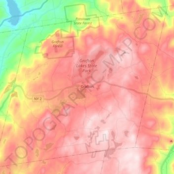
Name: Town of Grafton topographic map, elevation, terrain.
Location: Town of Grafton, Rensselaer County, New York, United States (42.71078 -73.54215 42.82636 -73.37236)
Average elevation: 393 m
Minimum elevation: 116 m
Maximum elevation: 553 m
Grafton possesses the most uneven surface of any town in the county. It is located within the limits of the Rensselaer Plateau and the principal peaks in the town reach an altitude of 1800 feet above the level of the sea. A small portion of the land only is arable, but the hillsides afford excellent grazing. Nevertheless, many of the inhabitants of Grafton have farms which, by years of constant care and cultivation, have been rendered almost as productive as any within the county.
Other topographic maps
Click on a map to view its topography, its elevation and its terrain.
City of Troy
United States > New York > Rensselaer County
City of Troy, Rensselaer County, New York, United States
Average elevation: 81 m
Troy
United States > New York > Rensselaer County
Troy, Rensselaer County, New York, 12181, United States
Average elevation: 137 m
Eagle Bridge
United States > New York > Rensselaer County > Town of Hoosick
Eagle Bridge, Town of Hoosick, Rensselaer County, New York, 12028, United States
Average elevation: 161 m
Town of Berlin
United States > New York > Rensselaer County
Town of Berlin, Rensselaer County, New York, United States
Average elevation: 482 m
East Greenbush
United States > New York > Rensselaer County > East Greenbush
East Greenbush, Town of East Greenbush, Rensselaer County, New York, United States
Average elevation: 97 m
Wynantskill
United States > New York > Rensselaer County
Wynantskill, Town of North Greenbush, Rensselaer County, New York, 12198, United States
Average elevation: 136 m
Schodack Center
United States > New York > Rensselaer County
Schodack Center, Town of Schodack, Rensselaer County, New York, 12033, United States
Average elevation: 117 m
Town of Sand Lake
United States > New York > Rensselaer County
Town of Sand Lake, Rensselaer County, New York, United States
Average elevation: 288 m
West Sand Lake
United States > New York > Rensselaer County > Town of Sand Lake
West Sand Lake, Town of Sand Lake, Rensselaer County, New York, 12196, United States
Average elevation: 181 m
Town of Petersburgh
United States > New York > Rensselaer County
Town of Petersburgh, Rensselaer County, New York, 12138, United States
Average elevation: 376 m
Averill Park
United States > New York > Rensselaer County > Town of Sand Lake
Averill Park, Town of Sand Lake, Rensselaer County, New York, United States
Average elevation: 246 m
Eagle Mills
United States > New York > Rensselaer County > Town of Brunswick
Eagle Mills, Town of Brunswick, Rensselaer County, New York, 12140, United States
Average elevation: 149 m
Town of Nassau
United States > New York > Rensselaer County
Town of Nassau, Rensselaer County, New York, 12062, United States
Average elevation: 167 m
Town of Pittstown
United States > New York > Rensselaer County
Town of Pittstown, Rensselaer County, New York, United States
Average elevation: 201 m
Speigletown
United States > New York > Rensselaer County > Town of Schaghticoke
Speigletown, Town of Schaghticoke, Rensselaer County, New York, 12182, United States
Average elevation: 136 m
Lansingburgh
United States > New York > Rensselaer County > City of Troy
Lansingburgh, City of Troy, Rensselaer County, New York, 12182, United States
Average elevation: 51 m
Walloomsac Dam
United States > New York > Rensselaer County > Town of Hoosick > Walloomsac
Walloomsac Dam, Walloomsac, Town of Hoosick, Rensselaer County, New York, 12133, United States
Average elevation: 191 m
Brainard
United States > New York > Rensselaer County > Town of Nassau
Brainard, Village of East Nassau, Town of Nassau, Rensselaer County, New York, 12024, United States
Average elevation: 216 m
Stephentown
United States > New York > Rensselaer County > Stephentown
Stephentown, Town of Stephentown, Rensselaer County, New York, 12168, United States
Average elevation: 311 m
Glass Lake
United States > New York > Rensselaer County > Town of Sand Lake
Glass Lake, Town of Sand Lake, Rensselaer County, New York, 12018, United States
Average elevation: 305 m
Town of East Greenbush
United States > New York > Rensselaer County
Town of East Greenbush, Rensselaer County, New York, United States
Average elevation: 89 m
Town of Brunswick
United States > New York > Rensselaer County
Town of Brunswick, Rensselaer County, New York, United States
Average elevation: 238 m
Buskirk
United States > New York > Rensselaer County
Buskirk, Rensselaer County, New York, 12028, United States
Average elevation: 152 m
Town of Schodack
United States > New York > Rensselaer County
Town of Schodack, Rensselaer County, New York, United States
Average elevation: 92 m
Town of Hoosick
United States > New York > Rensselaer County
Town of Hoosick, Rensselaer County, New York, United States
Average elevation: 242 m
Town of North Greenbush
United States > New York > Rensselaer County
Town of North Greenbush, Rensselaer County, New York, 12198, United States
Average elevation: 121 m
Village of Hoosick Falls
United States > New York > Rensselaer County > Town of Hoosick
Village of Hoosick Falls, Town of Hoosick, Rensselaer County, New York, 12090, United States
Average elevation: 166 m
Town of Poestenkill
United States > New York > Rensselaer County > Town of Poestenkill
Town of Poestenkill, Rensselaer County, New York, United States
Average elevation: 251 m
Poestenkill
United States > New York > Rensselaer County > Town of Poestenkill
Poestenkill, Town of Poestenkill, Rensselaer County, New York, 12140, United States
Average elevation: 194 m
Town of Stephentown
United States > New York > Rensselaer County
Town of Stephentown, Rensselaer County, New York, United States
Average elevation: 420 m
Nassau
United States > New York > Rensselaer County > Nassau
Nassau, Town of Nassau, Rensselaer County, New York, United States
Average elevation: 141 m
Burden Lake
United States > New York > Rensselaer County > Maple Grove
Burden Lake, Maple Grove, Town of Sand Lake, Rensselaer County, New York, United States
Average elevation: 224 m
Prospect Heights
United States > New York > Rensselaer County > Prospect Heights
Prospect Heights, Town of East Greenbush, Rensselaer County, New York, 12144-2920, United States
Average elevation: 43 m
Best
United States > New York > Rensselaer County > Best
Best, Town of East Greenbush, Rensselaer County, New York, 12016, United States
Average elevation: 167 m
Village of Schaghticoke
United States > New York > Rensselaer County > Town of Schaghticoke
Village of Schaghticoke, Town of Schaghticoke, Rensselaer County, New York, United States
Average elevation: 102 m