
Thank you for supporting this site ❤️
Make a donation
Make a donation
Glarus topographic map
Click on the map to display elevation.
Thank you for supporting this site ❤️
Make a donation
Make a donation
About this map
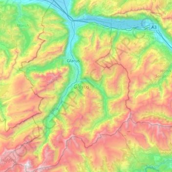
Name: Glarus topographic map, elevation, terrain.
Location: Glarus, Switzerland (46.79647 8.87123 47.17399 9.25258)
Average elevation: 1,612 m
Minimum elevation: 413 m
Maximum elevation: 3,565 m
Thank you for supporting this site ❤️
Make a donation
Make a donation
Other topographic maps
Click on a map to view its topography, its elevation and its terrain.
Kiental
Switzerland > Bern > Frutigen-Niedersimmental administrative district > Reichenbach im Kandertal
Average elevation: 1,363 m
Thank you for supporting this site ❤️
Make a donation
Make a donation
Brienz
Switzerland > Bern > Interlaken-Oberhasli administrative district > Brienz (BE)
Average elevation: 810 m
Under Tanneboumgrabe
Switzerland > Bern > Interlaken-Oberhasli administrative district > Unterseen > Tanneboum
Average elevation: 862 m
Thank you for supporting this site ❤️
Make a donation
Make a donation