
Hunedoara topographic map
Interactive map
Click on the map to display elevation.
About this map
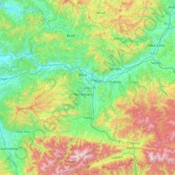
Name: Hunedoara topographic map, elevation, terrain.
Location: Hunedoara, Romania (45.23835 22.33601 46.35267 23.60168)
Average elevation: 710 m
Minimum elevation: 139 m
Maximum elevation: 2,455 m
Other topographic maps
Click on a map to view its topography, its elevation and its terrain.
Dorolea
Dorolea, Livezile, Bistrița-Năsăud, 427122, Romania
Average elevation: 488 m
Carpathian Mountains
Carpathian Mountains, Toplița, Harghita, 535705, Romania
Average elevation: 980 m
Dealul cu Drum
Dealul cu Drum, Greci, Tulcea, 827080, Romania
Average elevation: 168 m