
Thank you for supporting this site ❤️
Make a donation
Make a donation
Lupești topographic map
Click on the map to display elevation.
Thank you for supporting this site ❤️
Make a donation
Make a donation
About this map
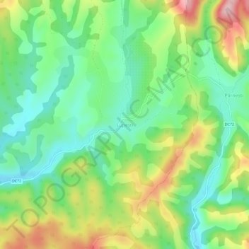
Name: Lupești topographic map, elevation, terrain.
Location: Lupești, Vărădia de Mureș, Arad, 317383, Romania (46.04938 22.19888 46.08938 22.23888)
Average elevation: 278 m
Minimum elevation: 199 m
Maximum elevation: 414 m
Thank you for supporting this site ❤️
Make a donation
Make a donation
Other topographic maps
Click on a map to view its topography, its elevation and its terrain.
Thank you for supporting this site ❤️
Make a donation
Make a donation
Thank you for supporting this site ❤️
Make a donation
Make a donation
Thank you for supporting this site ❤️
Make a donation
Make a donation
Thank you for supporting this site ❤️
Make a donation
Make a donation