
Thank you for supporting this site ❤️
Make a donation
Make a donation
Roanoke (city) topographic map
Click on the map to display elevation.
Thank you for supporting this site ❤️
Make a donation
Make a donation
About this map
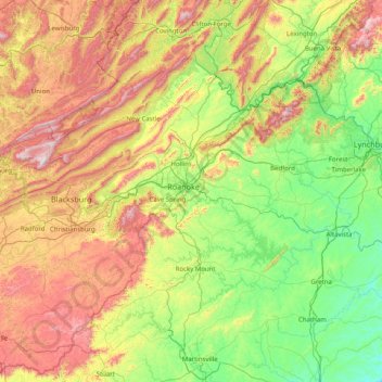
Name: Roanoke (city) topographic map, elevation, terrain.
Location: Roanoke (city), Virginia, 24013, United States of America (36.61292 -80.54938 37.89292 -79.26938)
Average elevation: 483 m
Minimum elevation: 105 m
Maximum elevation: 1,311 m
Thank you for supporting this site ❤️
Make a donation
Make a donation
Other topographic maps
Click on a map to view its topography, its elevation and its terrain.
Poquoson
United States of America > Virginia > Poquoson
Additionally, the geographic location of the city, with respect to the principal storm tracks, is generally favorable, as it is south of the usual path of storms originating in the higher latitudes, and north of the usual tracks of hurricanes and other major tropical storms. However, when in the path of a…
Average elevation: 2 m