
Thank you for supporting this site ❤️
Make a donation
Make a donation
Elburton Village topographic map
Click on the map to display elevation.
Thank you for supporting this site ❤️
Make a donation
Make a donation
About this map
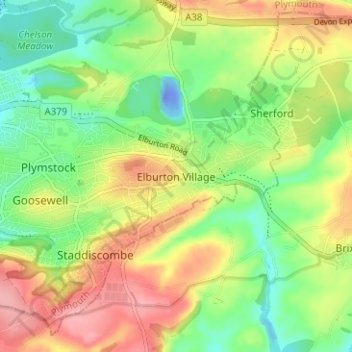
Name: Elburton Village topographic map, elevation, terrain.
Location: Elburton Village, Plymouth, England, PL9 8JL, United Kingdom (50.33897 -4.08835 50.37897 -4.04835)
Average elevation: 49 m
Minimum elevation: -40 m
Maximum elevation: 111 m
Thank you for supporting this site ❤️
Make a donation
Make a donation
Other topographic maps
Click on a map to view its topography, its elevation and its terrain.
Thank you for supporting this site ❤️
Make a donation
Make a donation
Thank you for supporting this site ❤️
Make a donation
Make a donation