
Make a donation
Campina Verde topographic map
Click on the map to display elevation.
Make a donation
About this map
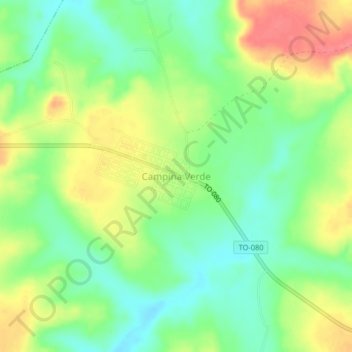
Name: Campina Verde topographic map, elevation, terrain.
Average elevation: 271 m
Minimum elevation: 242 m
Maximum elevation: 309 m
Make a donation
Other topographic maps
Click on a map to view its topography, its elevation and its terrain.
Gurupi
Gurupi, Tocantins is a city and a municipality in the Brazilian state of Tocantins. The estimated population was 87,545 inhabitants in 2020, the third-largest in the state, and the total area of the municipality was 1,836 km2. The elevation is around 287 meters in the city.
Average elevation: 280 m
Palmas
Palmas is one of the hottest capital cities in Brazil. During the May to September dry season, Palmas can be oppressively hot as temperatures climb into the high 30s (°C). During the October to April rainy season, it is not as hot. The heavy rains and cloud cover keep it much cooler. Palmas receives generous…
Average elevation: 367 m
Make a donation
Palmas
Palmas is located at the state's geographic centre at an average altitude of 230 m (755 ft). The city is located between the Serra do Lajeado hills on the east and the Tocantins River on the west. Palmas has a metropolitan area with 471,639 inhabitants.
Average elevation: 367 m
Make a donation
Make a donation
Make a donation
Make a donation
Natividade
The estimated population in 2020 was 9,250, the area is 3,240 km². The elevation is 323 m.
Average elevation: 372 m
Make a donation
Palmas
Palmas is one of the hottest capital cities in Brazil. During the May to September dry season, Palmas can be oppressively hot as temperatures climb into the high 30s (°C). During the October to April rainy season, it is not as hot. The heavy rains and cloud cover keep it much cooler. Palmas receives generous…
Average elevation: 367 m
Make a donation