
Thank you for supporting this site ❤️
Make a donation
Make a donation
Rakhine topographic map
Click on the map to display elevation.
Thank you for supporting this site ❤️
Make a donation
Make a donation
About this map
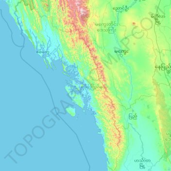
Name: Rakhine topographic map, elevation, terrain.
Location: Rakhine, Myanmar (17.33613 92.17292 21.47971 94.90184)
Average elevation: 156 m
Minimum elevation: -4 m
Maximum elevation: 2,962 m
Thank you for supporting this site ❤️
Make a donation
Make a donation
Other topographic maps
Click on a map to view its topography, its elevation and its terrain.