
Ancash topographic map
Click on the map to display elevation.
Ancash
The park territory is very uneven. It has snowy summits, which altitudes vary between 5000 and 6768 MSL. It also has gullies, that are deeply encased because of the fluvioglacial erosion, and a great number of lagoons. Inside the borders of the park, there are 663 glaciers that are distributed throughout 180 km, from the Tuku in the south up to the Champara in the north.
About this map
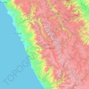
Name: Ancash topographic map, elevation, terrain.
Location: Ancash, Peru (-10.78731 -78.65848 -8.04971 -76.72574)
Average elevation: 2,121 m
Minimum elevation: 0 m
Maximum elevation: 6,632 m
Other topographic maps
Click on a map to view its topography, its elevation and its terrain.
Cuzco
Cusco or Cuzco (Spanish: [ˈkusko]; Quechua: Qosqo or Qusqu, pronounced [ˈqɔsqɔ]) is a city in southeastern Peru, near the Sacred Valley of the Andes mountain range and the Huatanay river. It is the capital of the eponymous province and department. The city is the seventh most populous in Peru; in 2017, it…
Average elevation: 3,790 m