
Thank you for supporting this site ❤️
Make a donation
Make a donation
Burgdorf topographic map
Click on the map to display elevation.
Thank you for supporting this site ❤️
Make a donation
Make a donation
About this map
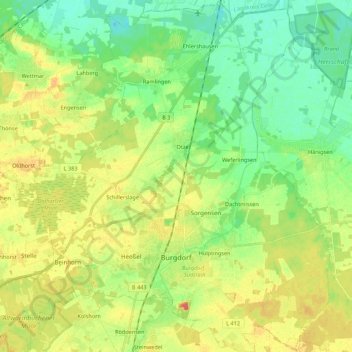
Name: Burgdorf topographic map, elevation, terrain.
Location: Burgdorf, Region Hannover, Nedersaksen, 31303, Duitsland (52.40794 9.91972 52.54047 10.10263)
Average elevation: 54 m
Minimum elevation: 36 m
Maximum elevation: 77 m
Thank you for supporting this site ❤️
Make a donation
Make a donation
Other topographic maps
Click on a map to view its topography, its elevation and its terrain.