
Vaumarcus topographic map
Interactive map
Click on the map to display elevation.
About this map
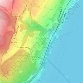
Name: Vaumarcus topographic map, elevation, terrain.
Location: Vaumarcus, La Grande-Béroche, Neuchâtel, 2028, Suisse (46.86790 6.73263 46.88438 6.76145)
Average elevation: 521 m
Minimum elevation: 422 m
Maximum elevation: 721 m
Other topographic maps
Click on a map to view its topography, its elevation and its terrain.
Gorgier
Suisse > Neuchâtel > La Grande-Béroche
Gorgier, La Grande-Béroche, Neuchâtel, 2023, Suisse
Average elevation: 743 m
Bevaix
Suisse > Neuchâtel > La Grande-Béroche
Bevaix, La Grande-Béroche, Neuchâtel, 2022, Suisse
Average elevation: 600 m
Saint-Aubin-Sauges
Suisse > Neuchâtel > La Grande-Béroche
Saint-Aubin-Sauges, La Grande-Béroche, Neuchâtel, 2024, Suisse
Average elevation: 667 m