
Bevaix topographic map
Interactive map
Click on the map to display elevation.
About this map
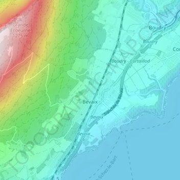
Name: Bevaix topographic map, elevation, terrain.
Location: Bevaix, La Grande-Béroche, Neuchâtel, 2022, Suisse (46.91527 6.77226 46.95008 6.83965)
Average elevation: 600 m
Minimum elevation: 422 m
Maximum elevation: 1,318 m
L'altitude minimum de Bevaix, le long du lac, est à 429 m, alors que le point le plus élevé se trouve à la petite Ecoeurne, au-dessus des rochers du Miroir, au Nord de la Fruitière de Bevaix, à 1 335 m.
Other topographic maps
Click on a map to view its topography, its elevation and its terrain.
Vaumarcus
Suisse > Neuchâtel > La Grande-Béroche
Vaumarcus, La Grande-Béroche, Neuchâtel, 2028, Suisse
Average elevation: 521 m
Gorgier
Suisse > Neuchâtel > La Grande-Béroche
Gorgier, La Grande-Béroche, Neuchâtel, 2023, Suisse
Average elevation: 743 m
Saint-Aubin-Sauges
Suisse > Neuchâtel > La Grande-Béroche
Saint-Aubin-Sauges, La Grande-Béroche, Neuchâtel, 2024, Suisse
Average elevation: 667 m