
Andalusia topographic map
Click on the map to display elevation.
Andalusia
Andalusia sits at a latitude between 36° and 38° 44' N, in the warm-temperate region. In general, it experiences a hot-summer Mediterranean climate, with dry summers influenced by the Azores High, but subject to occasional torrential rains and extremely hot temperatures. In the winter, the tropical anticyclones move south, allowing cold polar fronts to penetrate the region. Still, within Andalusia there is considerable climatic variety. From the extensive coastal plains one may pass to the valley of the Guadalquivir, barely above sea level, then to the highest altitudes in the Iberian peninsula in the peaks of the Sierra Nevada. In a mere 50 km (31 mi) one can pass from the subtropical coast of the province of Granada to the snowy peaks of Mulhacén. Andalusia also includes both the dry Tabernas Desert in the province of Almería and the Sierra de Grazalema Natural Park in the province of Cádiz, which experiences Spain's greatest rainfall.
About this map
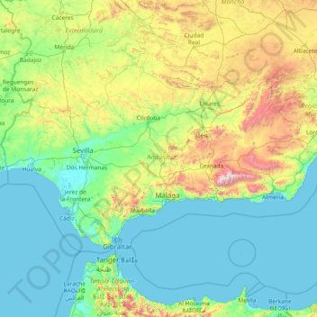
Name: Andalusia topographic map, elevation, terrain.
Location: Andalusia, Spain (35.93764 -7.52269 38.72909 -1.62980)
Average elevation: 378 m
Minimum elevation: -2 m
Maximum elevation: 3,273 m
Other topographic maps
Click on a map to view its topography, its elevation and its terrain.
Napal
Spain > Navarre > Zangozerria / Comarca de Sangüesa > Romanzado/Erromantzatua
Average elevation: 710 m
Muleta
Spain > Aragon > Matarraña / Matarranya > Valderrobres / Vall de Roures
Average elevation: 1,131 m
Piedra del Águila
Spain > Andalusia > Comarca de Huéscar > Puebla de Don Fadrique
Average elevation: 1,295 m
Soil
Spain > Autonomous Community of the Basque Country > Montaña Alavesa/Arabako Mendialdea
Average elevation: 898 m
Parque Alcalde José Sánchez
Spain > Campo de Cartagena y Mar Menor > San Pedro del Pinatar > Los Peñascos
Average elevation: 7 m
Cerro de Fabián
Spain > Andalusia > Sierra de Cádiz > Villaluenga del Rosario
Average elevation: 736 m
Cerro Teresa
Spain > Castile-La Mancha > Mesa de Ocaña > Santa Cruz de la Zarza
Average elevation: 774 m