
Make a donation
Pyin Oo Lwin topographic map
Click on the map to display elevation.
Make a donation
Pyin Oo Lwin
Pyin Oo Lwin or Pyin U Lwin (Burmese: ပြင်ဦးလွင်မြို့; MLCTS: prang u: lwang mrui., pronounced [pjɪ̀ɰ̃ ʔú lwɪ̀ɰ̃]; Shan: ဝဵင်းပၢင်ႇဢူႈ), formerly and colloquially referred to as Maymyo (Burmese: မေမြို့; MLCTS: me mrui.), is a scenic hill town in the Mandalay Region, Myanmar, some 67 kilometers (42 mi) east of Mandalay, and at an elevation of 1,070 metres (3,510 ft). The town was estimated to have a population of around 255,000 in 2014.
Make a donation
About this map
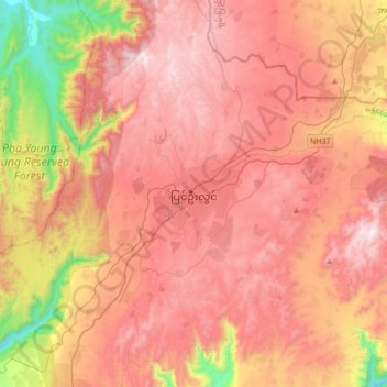
Name: Pyin Oo Lwin topographic map, elevation, terrain.
Location: Pyin Oo Lwin, Pyinoolwin Township, Mandalay, 08520, Myanmar (21.87314 96.30673 22.19314 96.62673)
Average elevation: 913 m
Minimum elevation: 123 m
Maximum elevation: 1,449 m
Make a donation
Other topographic maps
Click on a map to view its topography, its elevation and its terrain.
Make a donation
Make a donation
Make a donation
Make a donation
Make a donation
Make a donation
Ayeyarwaddy International School
Myanmar > Mandalay > Mandalay District > Mandalay > Chanayethazan Township
Average elevation: 78 m