
Make a donation
Myingyan Township topographic map
Click on the map to display elevation.
Make a donation
About this map
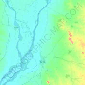
Name: Myingyan Township topographic map, elevation, terrain.
Location: Myingyan Township, Myingyan District, Mandalay, 05251, Myanmar (21.33792 95.24782 21.77080 95.63078)
Average elevation: 107 m
Minimum elevation: 51 m
Maximum elevation: 465 m
Make a donation
Other topographic maps
Click on a map to view its topography, its elevation and its terrain.
Pyin Oo Lwin
Pyin Oo Lwin or Pyin U Lwin (Burmese: ပြင်ဦးလွင်မြို့; MLCTS: prang u: lwang mrui., pronounced [pjɪ̀ɰ̃ ʔú lwɪ̀ɰ̃]; Shan: ဝဵင်းပၢင်ႇဢူႈ, Weng Pang U), formerly and colloquially referred to as Maymyo (Burmese: မေမြို့; MLCTS: me…
Average elevation: 913 m
Pyin Oo Lwin
Pyin Oo Lwin or Pyin U Lwin (Burmese: ပြင်ဦးလွင်မြို့, MLCTS: prang u: lwang mrui., pronounced [pjɪ̀ɰ̃ ʔú lwɪ̀ɰ̃]; Shan: ဝဵင်းပၢင်ႇဢူႈ, Weng Pang U), formerly and colloquially referred to as Maymyo (Burmese: မေမြို့, MLCTS: me…
Average elevation: 913 m
Make a donation
Pyin Oo Lwin
Pyin Oo Lwin or Pyin U Lwin (Burmese: ပြင်ဦးလွင်မြို့; MLCTS: prang u: lwang mrui., pronounced [pjɪ̀ɰ̃ ʔú lwɪ̀ɰ̃]; Shan: ဝဵင်းပၢင်ႇဢူႈ), formerly and colloquially referred to as Maymyo (Burmese: မေမြို့; MLCTS: me mrui.), is a…
Average elevation: 913 m
Pyin Oo Lwin
Pyin Oo Lwin or Pyin U Lwin (Burmese: ပြင်ဦးလွင်မြို့, MLCTS: prang u: lwang mrui., pronounced [pjɪ̀ɰ̃ ʔú lwɪ̀ɰ̃]; Shan: ဝဵင်းပၢင်ႇဢူႈ, Weng Pang U), formerly and colloquially referred to as Maymyo (Burmese: မေမြို့, MLCTS: me…
Average elevation: 913 m
Pyin Oo Lwin
Pyin Oo Lwin or Pyin U Lwin (Burmese: ပြင်ဦးလွင်မြို့, MLCTS: prang u: lwang mrui., pronounced [pjɪ̀ɰ̃ ʔú lwɪ̀ɰ̃]; Shan: ဝဵင်းပၢင်ႇဢူႈ, Weng Pang U), formerly and colloquially referred to as Maymyo (Burmese: မေမြို့, MLCTS: me…
Average elevation: 913 m
Make a donation
Make a donation
Make a donation
Make a donation
Make a donation
Make a donation
Make a donation
Mogok
At 1,170 metres (3,840 ft) in elevation, the city has a fairly temperate climate year-round, and is home to Bamar, Shan, Lisu, Palaung, and Karen ethnic groups, as well as Chinese, Indians and Gurkhas. The city is composed of two towns, Mogok and Kyat Pyin. Mogok is four miles long and two miles wide. It is…
Average elevation: 993 m
Ayeyarwaddy International School
Myanmar > Mandalay > Mandalay District > Mandalay > Chanayethazan Township
Average elevation: 78 m
Zay Kone စျေးကုန်း
Myanmar > Mandalay > Kyaukse District > Myittha Township > Zay Kone စျေးကုန်း
Average elevation: 100 m
Make a donation