
Ciergnon topographic map
Interactive map
Click on the map to display elevation.
Ciergnon
Op een hoogte aan de samenvloeiing van de Lesse en de Vachaux ligt het koninklijk Kasteel van Ciergnon (1842). Naast dit kasteel kent Ciergnon nog twee andere kastelen, en wel.
About this map
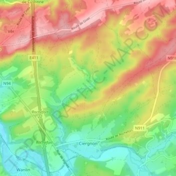
Name: Ciergnon topographic map, elevation, terrain.
Location: Ciergnon, Houyet, Dinant, Namen, Wallonië, België (50.16259 5.04251 50.20169 5.11989)
Average elevation: 204 m
Minimum elevation: 122 m
Maximum elevation: 299 m
Other topographic maps
Click on a map to view its topography, its elevation and its terrain.
Chairière
Chairière is een dorp in de Belgische provincie Namen en een deelgemeente van Vresse-sur-Semois. Het dorpje ligt nabij een meander van de Semois. De meeste nieuwe bebouwing is ontstaan ter hoogte van de grote weg door het dorp (N945), het kerkje en de kleine dorpskern liggen echter een paar honderd meter…
Average elevation: 280 m
Agimont
De naam Agimont is een samentrekking van Au Givet Mont wat letterlijk hoogte die uitkijkt op Givet betekent. Er was reeds vroeg een versterkte burcht om de streek te beschermen. Reeds vroeg ontstond het graafschap Agimont dat onder de vleugels stond van het prinsbisdom Luik en het was bezit van verscheidene…
Average elevation: 166 m
Rienne
Rienne is een dorp in de Belgische provincie Namen en een deelgemeente van Gedinne. Het ligt ruim vier kilometer ten westen van Gedinne-centrum, en is met zijn ruim 700 inwoners de op een na meest bevolkte deelgemeente, na Gedinne-centrum. Het grondgebied van Rienne is zo geaccidenteerd, dat men vanaf sommige…
Average elevation: 369 m