
Thank you for supporting this site ❤️
Make a donation
Make a donation
Cochabamba topographic map
Click on the map to display elevation.
Thank you for supporting this site ❤️
Make a donation
Make a donation
About this map
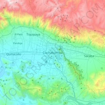
Name: Cochabamba topographic map, elevation, terrain.
Location: Cochabamba, Kanata, Cercado, Cochabamba, 922, Bolivia (-17.55361 -66.31690 -17.23361 -65.99690)
Average elevation: 3,145 m
Minimum elevation: 2,507 m
Maximum elevation: 4,825 m
Thank you for supporting this site ❤️
Make a donation
Make a donation
Other topographic maps
Click on a map to view its topography, its elevation and its terrain.
Thank you for supporting this site ❤️
Make a donation
Make a donation
Cochabamba
Bolivia > Cochabamba > Cercado > Cochabamba
The valley of Cochabamba has been classified as a mesothermal valley. The basin floor has an average elevation of 2600 m but at its lowest point in the east it runs at 2480 m. Surrounding mountains vary in height with the highest elevation in vicinity of valley being Tunari with 5,023 m a.s.l. The city is…
Average elevation: 2,953 m