
Make a donation
Cochabamba topographic map
Click on the map to display elevation.
Make a donation
Cochabamba
The valley of Cochabamba has been classified as a mesothermal valley. The basin floor has an average elevation of 2600 m but at its lowest point in the east it runs at 2480 m. Surrounding mountains vary in height with the highest elevation in vicinity of valley being Tunari with 5,023 m a.s.l. The city is primarily built on the Cenozoic and more specifically, Quaternary sedimentary fill of the basin-valley. Mountains and hills are composed of old rocks dating to the Paleozoic and, in some parts, to the Cretaceous.
Make a donation
About this map
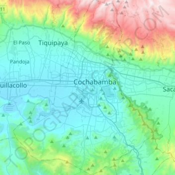
Name: Cochabamba topographic map, elevation, terrain.
Average elevation: 2,953 m
Minimum elevation: 2,535 m
Maximum elevation: 4,516 m
Make a donation
Other topographic maps
Click on a map to view its topography, its elevation and its terrain.