
Thank you for supporting this site ❤️
Make a donation
Make a donation
Keflavík topographic map
Click on the map to display elevation.
Thank you for supporting this site ❤️
Make a donation
Make a donation
About this map
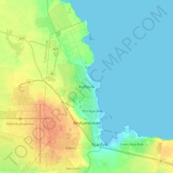
Name: Keflavík topographic map, elevation, terrain.
Location: Keflavík, Reykjanesbær, Southern Peninsula, 230, Iceland (63.95977 -22.59654 64.03977 -22.51654)
Average elevation: 19 m
Minimum elevation: -1 m
Maximum elevation: 67 m
Thank you for supporting this site ❤️
Make a donation
Make a donation
Other topographic maps
Click on a map to view its topography, its elevation and its terrain.