
Thank you for supporting this site ❤️
Make a donation
Make a donation
Hampton County topographic map
Click on the map to display elevation.
Thank you for supporting this site ❤️
Make a donation
Make a donation
About this map
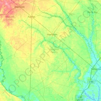
Name: Hampton County topographic map, elevation, terrain.
Location: Hampton County, South Carolina, United States (32.55109 -81.42752 33.02658 -80.82725)
Average elevation: 27 m
Minimum elevation: -5 m
Maximum elevation: 94 m
Thank you for supporting this site ❤️
Make a donation
Make a donation
Other topographic maps
Click on a map to view its topography, its elevation and its terrain.
Thank you for supporting this site ❤️
Make a donation
Make a donation
Deerwood Heights
United States > South Carolina > Charleston County > North Charleston
Average elevation: 8 m
Thank you for supporting this site ❤️
Make a donation
Make a donation