
Cheras topographic map
Interactive map
Click on the map to display elevation.
About this map
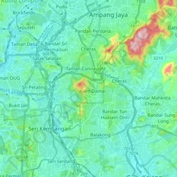
Name: Cheras topographic map, elevation, terrain.
Location: Cheras, Kuala Lumpur, Malaysia (2.99460 101.70600 3.13905 101.80236)
Average elevation: 74 m
Minimum elevation: 12 m
Maximum elevation: 399 m
Other topographic maps
Click on a map to view its topography, its elevation and its terrain.
Kampung Hujung Pasir
Kampung Hujung Pasir, Kampung Bharu, Kuala Lumpur, 50300, Malaysia
Average elevation: 46 m
Kampung Kasipillay
Kampung Kasipillay, Kuala Lumpur, 51000, Malaysia
Average elevation: 54 m
Titiwangsa Lake Park
Titiwangsa Lake Park, Semarak, Kuala Lumpur, Malaysia
Average elevation: 43 m
Duta Nusantara Park
Duta Nusantara Park, Duta Nusantara, Taman Duta, Kuala Lumpur, Malaysia
Average elevation: 82 m