
Thank you for supporting this site ❤️
Make a donation
Make a donation
Oreye topographic map
Click on the map to display elevation.
Thank you for supporting this site ❤️
Make a donation
Make a donation
About this map
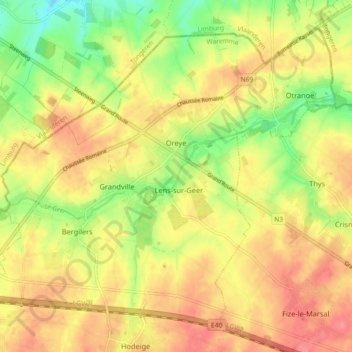
Name: Oreye topographic map, elevation, terrain.
Location: Oreye, Waremme, Liège, Wallonie, 4360, Belgique (50.69941 5.30393 50.74797 5.39447)
Average elevation: 115 m
Minimum elevation: 78 m
Maximum elevation: 142 m
Thank you for supporting this site ❤️
Make a donation
Make a donation
Other topographic maps
Click on a map to view its topography, its elevation and its terrain.