
Make a donation
Lake Van topographic map
Click on the map to display elevation.
Make a donation
Lake Van
Lake Van (Turkish: Van Gölü; Armenian: Վանա լիճ, romanized: Vana lič̣; Kurdish: Gola Wanê) is the largest lake in Turkey.[3][4] It lies in the far east of Turkey, in the provinces of Van and Bitlis in the Armenian highlands. It is a saline soda lake, receiving water from many small streams that descend from the surrounding mountains. It is one of the world's few endorheic lakes (a lake having no outlet) of size greater than 3,000 square kilometres (1,200 sq mi) and has 38% of the country's surface water (including rivers). A volcanic eruption blocked its original outlet in prehistoric times. It is situated at 1,640 m (5,380 ft) above sea level. Despite the high altitude and winter highs below 0 °C (32 °F), high salinity usually prevents it from freezing; the shallow northern section can freeze, but rarely.[5]
Make a donation
About this map
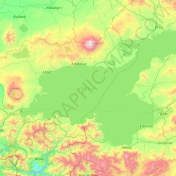
Name: Lake Van topographic map, elevation, terrain.
Location: Lake Van, Bitlis, Eastern Anatolia Region, Turkey (38.30748 42.28754 39.00507 43.66007)
Average elevation: 1,902 m
Minimum elevation: 1,190 m
Maximum elevation: 4,021 m
Make a donation
Other topographic maps
Click on a map to view its topography, its elevation and its terrain.
Make a donation
Pontic Mountains
Winter conditions are very harsh, and snow even in summer months isn't unusual above certain elevations.
Average elevation: 2,800 m
Make a donation
Make a donation
Make a donation
Make a donation
Make a donation
Make a donation
Make a donation
Make a donation
Make a donation
Make a donation
Make a donation
Make a donation
Make a donation
Make a donation
Make a donation
Mount Erciyes
The climate of the region is influenced by topography, with the Taurus and Kaçkar Mountains blocking the entry of moisture into Anatolia. Summers are dry and hot and winters wet and cold; in Kayseri, summer temperatures are about 19 °C (66 °F) and winter temperature about 0 °C (32 °F). Precipitation at…
Average elevation: 3,329 m
Make a donation
Make a donation
Keban Dam
The Keban Dam is a combined rockfill and concrete gravity hydroelectric dam operated by the State Hydraulic Works (DSİ). The dam is 1,097 metres (3,599 ft) long and its crest is 207 metres (679 ft) above the level of the river-bed (848 metres (2,782 ft) above sea-level). Its eight water turbines are capable…
Average elevation: 844 m
Make a donation
Make a donation
Make a donation
Make a donation
Make a donation
Make a donation
Make a donation