
Thank you for supporting this site ❤️
Make a donation
Make a donation
Çamiçi topographic map
Click on the map to display elevation.
Thank you for supporting this site ❤️
Make a donation
Make a donation
About this map
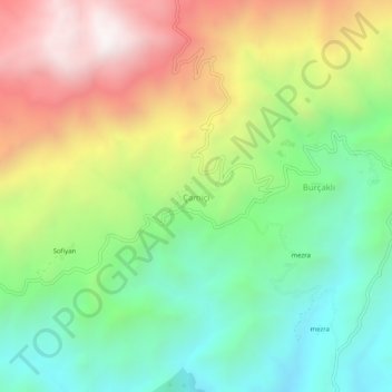
Name: Çamiçi topographic map, elevation, terrain.
Location: Çamiçi, Gerger, Adıyaman, Southeastern Anatolia Region, Turkey (38.01750 38.91985 38.05750 38.95985)
Average elevation: 1,191 m
Minimum elevation: 690 m
Maximum elevation: 1,921 m
Thank you for supporting this site ❤️
Make a donation
Make a donation