
Make a donation
Zacatecas topographic map
Click on the map to display elevation.
Make a donation
Zacatecas
The state has an average altitude of 2230 meters above sea level, with the capital at 2,496 masl. The state has three main geographical regions, the Sierra Madre Occidental in the west, the Mexican Plateau and the Sierra Madre Oriental. Most of it is in the Sierra Madre Occidental with highly rugged peaks of over 2,500 meters above sea level. The mountains of the southeast and northeast are lower but there are large valleys such as the Juchipila and Tlaltenango. Most of the territory has only small mesas and other areas of flat land. In the center of the state there is a small mountain chain called the Sierra de Fresnillo, from which much of the state's mineral wealth comes. In the extreme northwest there is another important mountain chain called the Sierra de Sombrerete, marked by a mountain called Sombreretillo, which is an important source of mineral wealth. Near this chain is another called the Sierra de Órganos.
Make a donation
About this map
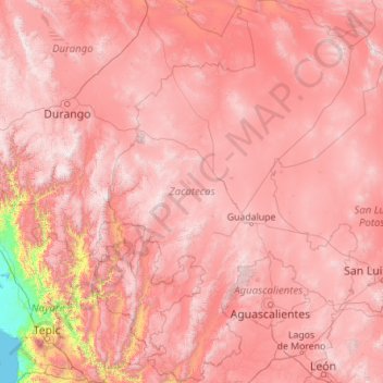
Name: Zacatecas topographic map, elevation, terrain.
Location: Zacatecas, Mexico (21.04187 -104.35353 25.12524 -100.74232)
Average elevation: 1,875 m
Minimum elevation: -1 m
Maximum elevation: 3,240 m
Make a donation
Other topographic maps
Click on a map to view its topography, its elevation and its terrain.
Make a donation
Villahermosa
Villahermosa is located in the southeast of Mexico between the rivers Grijalva and Carrizal. The average elevation of the city is 10 meters above sea level. The city also has several lagoons, the largest and most important of them being La Laguna de las Ilusiones (Illusions Lagoon).
Average elevation: 9 m
Make a donation
Acapulco
Mexico > Guerrero > Acapulco de Juárez
The city, located on the Pacific coast of Mexico in the state of Guerrero, is classified as one of the state's seven regions, dividing the rest of the Guerrero coast into the Costa Grande and the Costa Chica. Forty percent of the municipality is mountainous terrain; another forty percent is semi-flat; and the…
Average elevation: 99 m
Ciudad Juárez
Due to its location in the Chihuahuan Desert and high altitude, Ciudad Juárez has a cold desert climate (Köppen: BWk). Seasons are distinct, with hot summers, mild springs and autumns, and cold winters. Summer average high is 35 °C (95 °F) with lows of 21 °C (70 °F). Winter highs average 14 °C (57 °F)…
Average elevation: 1,228 m
Make a donation
Make a donation
Make a donation
Make a donation