
Villecomtal-sur-Arros topographic map
Interactive map
Click on the map to display elevation.
About this map
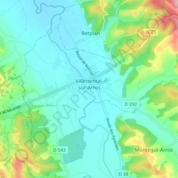
Name: Villecomtal-sur-Arros topographic map, elevation, terrain.
Average elevation: 206 m
Minimum elevation: 167 m
Maximum elevation: 331 m
L'altitude de la commune varie entre 168 et 315 mètres.
Other topographic maps
Click on a map to view its topography, its elevation and its terrain.
Au Thuillie
France > Occitanie > Gers > Cazaubon
Au Thuillie, Sentou, Cazaubon, Condom, Gers, Occitanie, France métropolitaine, 32150, France
Average elevation: 121 m