
Grimisuat topographic map
Interactive map
Click on the map to display elevation.
About this map
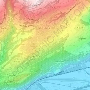
Name: Grimisuat topographic map, elevation, terrain.
Location: Grimisuat, Sion, Valais, 1971, Suisse (46.24352 7.36340 46.26755 7.40325)
Average elevation: 752 m
Minimum elevation: 490 m
Maximum elevation: 1,079 m
Other topographic maps
Click on a map to view its topography, its elevation and its terrain.
Becca d'Audon
Suisse > Valais > Sion > Savièse
Becca d'Audon, Savièse, Sion, Région administrative de l'Oberland, Valais, 1965, Suisse
Average elevation: 2,606 m
Les Agettes
Suisse > Valais > Sion > Sion > Les Agettes
Les Agettes, Sion, Valais, 1992, Suisse
Average elevation: 1,395 m