
Thank you for supporting this site ❤️
Make a donation
Make a donation
Otago topographic map
Click on the map to display elevation.
Thank you for supporting this site ❤️
Make a donation
Make a donation
About this map
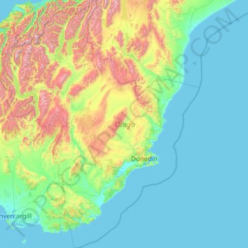
Name: Otago topographic map, elevation, terrain.
Location: Otago, New Zealand (-46.83936 168.11639 -43.95541 171.41813)
Average elevation: 348 m
Minimum elevation: -2 m
Maximum elevation: 2,681 m
Thank you for supporting this site ❤️
Make a donation
Make a donation
Other topographic maps
Click on a map to view its topography, its elevation and its terrain.
Thank you for supporting this site ❤️
Make a donation
Make a donation
Christmas Village
New Zealand > Southland > Southland District > Stewart Island / Rakiura Community
Average elevation: 85 m
Murray Beach
New Zealand > Southland > Southland District > Stewart Island / Rakiura Community
Average elevation: 48 m
Thank you for supporting this site ❤️
Make a donation
Make a donation
Merrivale
New Zealand > Southland > Southland District > Tuatapere Te Waewae Community
Average elevation: 192 m
Thank you for supporting this site ❤️
Make a donation
Make a donation
Castle Hill
New Zealand > Southland > Southland District > Northern Community
Average elevation: 569 m
Thank you for supporting this site ❤️
Make a donation
Make a donation