
Thank you for supporting this site ❤️
Make a donation
Make a donation
Ayeyarwady topographic map
Click on the map to display elevation.
Thank you for supporting this site ❤️
Make a donation
Make a donation
About this map
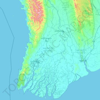
Name: Ayeyarwady topographic map, elevation, terrain.
Location: Ayeyarwady, Myanmar (15.66953 94.19115 18.51085 96.08078)
Average elevation: 44 m
Minimum elevation: -3 m
Maximum elevation: 1,220 m
Thank you for supporting this site ❤️
Make a donation
Make a donation
Other topographic maps
Click on a map to view its topography, its elevation and its terrain.