Geolocate

Pontevedra topographic map

Interactive map

Click on the map to display elevation.

About this map

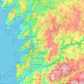
Name: Pontevedra topographic map, elevation, terrain.

Location: Pontevedra, Galicia, Spain (41.86393 -8.94963 42.86016 -7.86143)

Average elevation: 339 m

Minimum elevation: -2 m

Maximum elevation: 1,399 m

Other topographic maps

Click on a map to view its topography, its elevation and its terrain.

Ceza

Spain > Galicia > Lugo

Average elevation: 447 m

Guille

Spain > Galicia > O Condado > As Neves

Average elevation: 402 m

Hospital

Spain > Galicia > Os Ancares > Pedrafita do Cebreiro

Average elevation: 1,174 m

A Coruña

Spain > Galicia > A Coruña

Average elevation: 67 m

Santiago de Compostela

Spain > Galicia > Santiago

The cathedral borders the main plaza of the old and well-preserved city. According to medieval legend, the remains of the apostle James were brought to Galicia for burial; in 813, the light of a bright star guided a shepherd who was watching his flock at night to the burial site in Santiago de Compostela. This…

Average elevation: 248 m

Province

Spain > Galicia > Province

Average elevation: 465 m

Santa Magdalena

Spain > Galicia

Average elevation: 459 m

Ferrol

Spain > Galicia > Ferrol > Ferrol

Average elevation: 98 m