
Jharkhand topographic map
Interactive map
Click on the map to display elevation.
About this map
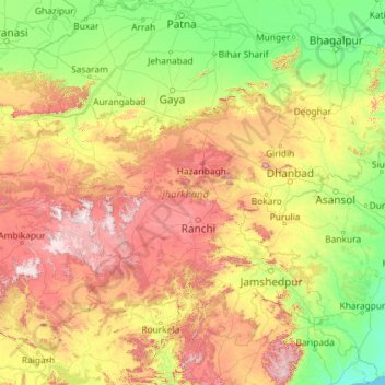
Name: Jharkhand topographic map, elevation, terrain.
Location: Jharkhand, India (21.97003 83.32811 25.34892 87.96277)
Average elevation: 277 m
Minimum elevation: 0 m
Maximum elevation: 1,192 m
Other topographic maps
Click on a map to view its topography, its elevation and its terrain.
Chennai
India > Tamil Nadu > Chennai
Chennai, Chennai District, Tamil Nadu, India
Average elevation: 8 m
Bengaluru
India > Karnataka > Bangalore North
Bengaluru, Bangalore North, Bengaluru Urban District, Karnataka, India
Average elevation: 881 m
3d
India > Rajasthan > Ganganagar Tehsil > 1 LNP
3d, 1 LNP, Ganganagar Tehsil, Sri Ganganagar District, Rajasthan, India
Average elevation: 178 m
Thiruvananthapuram
India > Kerala > Thiruvananthapuram
Thiruvananthapuram, Thiruvananthapuram District, Kerala, 695001, India
Average elevation: 33 m
North Sentinel Island
India > Andaman and Nicobar Islands > Ferrargunj
North Sentinel Island, Ferrargunj, South Andaman District, Andaman and Nicobar Islands, India
Average elevation: 20 m
Sehore
India > Madhya Pradesh > Sehore Nagar Tahsil
Sehore, Sehore Nagar Tahsil, Sehore District, Madhya Pradesh, 466002, India
Average elevation: 501 m
Kukshi
India > Madhya Pradesh > Bhavra Tehsil
Kukshi, Bhavra Tehsil, Alirajpur District, Madhya Pradesh, India
Average elevation: 403 m
Thoothukudi
India > Tamil Nadu > Thoothukkudi
Thoothukudi, Thoothukkudi, Thoothukudi District, Tamil Nadu, 628001, India
Average elevation: 10 m
Hanagal taluk
Hanagal taluk, Haveri District, Karnataka, India
Average elevation: 571 m
Whitefield
India > Karnataka > Bangalore East > Bengaluru
Whitefield, Bengaluru, Bangalore East, Bengaluru Urban District, Karnataka, 560066, India
Average elevation: 875 m
Bachupally mandal
Bachupally mandal, Medchal–Malkajgiri District, Telangana, 500090, India
Average elevation: 593 m
Mysuru
India > Karnataka > Mysuru taluk
Mysuru, Mysuru taluk, Mysuru District, Karnataka, 570001, India
Average elevation: 727 m
Lucknow
India > Uttar Pradesh > Lucknow
Lucknow, Lucknow District, Uttar Pradesh, 226027, India
Average elevation: 120 m
Jaipur
India > Rajasthan > Jaipur Tehsil
Jaipur, Jaipur Municipal Corporation, Jaipur Tehsil, Jaipur District, Rajasthan, 302001, India
Average elevation: 408 m
Pune
India > Maharashtra > Pune City > Pune
Pune, Pune City, Pune District, Maharashtra, 411001, India
Average elevation: 641 m
Kolkata
Kolkata, Kolkata District, West Bengal, 700073, India
Average elevation: 5 m
Panaiyur
India > Tamil Nadu > Mannargudi
Panaiyur, Mannargudi, Thiruvarur District, Tamil Nadu, 614717, India
Average elevation: 7 m
Malihabad
Malihabad, Lucknow District, Uttar Pradesh, India
Average elevation: 127 m
Palghar
India > Maharashtra > Palghar Taluka
Palghar, Palghar Taluka, Palghar District, Maharashtra, 401400, India
Average elevation: 19 m
Kallikudi
India > Tamil Nadu > Srirangam
Kallikudi, Srirangam, Tiruchirappalli District, Tamil Nadu, 620102, India
Average elevation: 83 m
Singpur
India > Madhya Pradesh > Gadarwara Tahsil
Singpur, Gadarwara Tahsil, Narsinghpur District, Madhya Pradesh, India
Average elevation: 366 m
Shamshabad Reserved Forest
India > Madhya Pradesh > Vidisha Tahsil > Hinotiya
Shamshabad Reserved Forest, Hinotiya, Vidisha Tahsil, Vidisha District, Madhya Pradesh, India
Average elevation: 469 m
Sheoganj
India > Rajasthan > Sheoganj Tehsil
Sheoganj, Sheoganj Tehsil, Sirohi District, Rajasthan, 306902, India
Average elevation: 271 m
Pimpri-Chinchwad
India > Maharashtra > Haveli
Pimpri-Chinchwad, Haveli, Pune District, Maharashtra, 411089, India
Average elevation: 605 m
Jaisalmer Tehsil
Jaisalmer Tehsil, Jaisalmer District, Rajasthan, India
Average elevation: 140 m
Mekkunnu
India > Kerala > Thalassery
Mekkunnu, Thalassery, Kannur District, Kerala, 670675, India
Average elevation: 19 m
Western Ghats
Western Ghats, Idukki, Kerala, 685614, India
Average elevation: 2,225 m