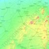
Assam topographic map
Click on the map to display elevation.
About this map
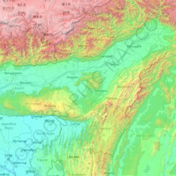
Name: Assam topographic map, elevation, terrain.
Location: Assam, India (24.13603 89.69860 27.97124 96.01244)
Average elevation: 1,142 m
Minimum elevation: -2 m
Maximum elevation: 7,324 m
Other topographic maps
Click on a map to view its topography, its elevation and its terrain.

Dehradun
India > Uttarakhand > Dehradun
The city of Dehradun mainly lies in Doon Valley and is at a varying height from 410 m (1,350 ft) in Clement Town to above 700 m (2,300 ft) at Malsi which is 15 km (9.3 mi) from the city. However, the average elevation is 450 m (1,480 ft) above sea level. Malsi is the starting point of Lesser Himalayan Range…
Average elevation: 904 m
Surat
India > Gujarat > Katargam Taluka > Surat
Surat is a port city situated on the banks of the Tapi river. Damming of the Tapi caused the original port facilities to close; the nearest port is now in the Magadalla and Hazira area of Surat Metropolitan Region.It has famous beach called 'Dumas Beach' located in Hazira. The city is located at 21°10′N…
Average elevation: 11 m

Dakshina Kannada
The topography of the district is plain up to 30 km (18.64 mi) inside the coast and changes to undulating hilly terrain sharply towards the east in the Western Ghats. Teak, bamboo and rosewood trees are found in the hilly areas towards the east. The Geological Survey of India has identified this district as a…
Average elevation: 109 m
Vijayawada
India > Andhra Pradesh > Vijayawada (Urban)
Vijayawada lies on the banks of Krishna river, covered by hills and canals. and at an altitude of 11 m (36 ft) above sea level. Three canals originating from the north side of the Prakasam Barrage reservoir — Eluru, Bandar, and Ryves — flow through the city.
Average elevation: 37 m
Mumbai
Mumbai lies at the mouth of the Ulhas River on the western coast of India, in the coastal region known as the Konkan. It sits on Salsette Island (Sashti Island), which it partially shares with the Thane district. Mumbai is bounded by the Arabian Sea to the west. Many parts of the city lie just above sea level,…
Average elevation: 13 m
Mangaluru
India > Karnataka > Mangaluru taluk
Mangalore is also the administrative headquarters of the Dakshina Kannada district; it is a commercial, industrial, educational, healthcare, and startup hub. The city's international airport is the second-largest and second-busiest airport in Karnataka. Mangalore City Corporation is responsible for the civic…
Average elevation: 25 m
Lucknow
India > Uttar Pradesh > Lucknow
Lucknow stands at an elevation of approximately 123 metres (404 ft) above sea level. The city had an area of 402 km2 (155 square miles) until December 2019, when 88 villages were added to the municipal limits and the area increased to 631 km2 (244 square miles). Bounded on the east by Barabanki, on the west by…
Average elevation: 120 m



Mysuru
India > Karnataka > Mysuru taluk
Mysore (/maɪˈsɔːr/ (listen)), officially Mysuru ([ˈmaɪˈsuːɾu] (listen)), is a city in the southern part of the state of Karnataka, India. Mysore city is geographically located between 12° 18′ 26″ north latitude and 76° 38′ 59″ east longitude. It is located at an altitude of 770 m (2,530 ft)…
Average elevation: 727 m
Navi Mumbai
India > Maharashtra > Thane > Navi Mumbai
Navi Mumbai (Marathi pronunciation: , also known by its former name New Bombay), is a planned city off the west coast of the Indian state of Maharashtra in Konkan division. The city is divided into two parts, North Navi Mumbai and South Navi Mumbai, for the individual development of Panvel Mega City, which…
Average elevation: 30 m
Bhopal
India > Madhya Pradesh > Huzur Tahsil
Bhopal has an average elevation of 500 metres (1401 ft) and is located in the central part of India, just north of the upper limit of the Vindhya mountain ranges. Located on the Malwa plateau, it is higher than the north Indian plains and the land rises towards the Vindhya Range to the south. The city has…
Average elevation: 498 m







Mysuru
India > Karnataka > Mysuru taluk
Mysore (/maɪˈsɔːr/ (listen)), officially Mysuru ([ˈmaɪˈsuːɾu] (listen)), is a city in the southern part of the state of Karnataka, India. Mysore city is geographically located between 12° 18′ 26″ north latitude and 76° 38′ 59″ east longitude. It is located at an altitude of 770 m (2,530 ft)…
Average elevation: 727 m


Beed
India > Maharashtra > Beed
The Shahinshah Wali tomb: Shahinshah Wali was a Sufi of the 14th century from Chishtiya clan. He came to Beed during the rule of Muhammad Tughluq. His tomb and surrounding areas were built in different periods from 1385 to 1840. The details can be seen in the history of Beed. It is situated on the eastern…
Average elevation: 563 m
Sarahan
India > Himachal Pradesh > Rampur
Sarahan is located at 31°31′N 77°48′E / 31.52°N 77.80°E / 31.52; 77.80. It has an average elevation of 2,313 metres (7,589 feet).
Average elevation: 2,204 m



Jaynagar Majilpur
India > West Bengal > Jaynagar - I
Jaynagar Majilpur is located at 22°10′31″N 88°25′12″E / 22.1751965°N 88.4200762°E / 22.1751965; 88.4200762. It has an average elevation of 8 metres (26 ft).
Average elevation: 5 m
Bengaluru
India > Karnataka > Bangalore North
Bengaluru lies in the southeast of the South Indian state of Karnataka in the heart of the Mysore Plateau (a region of the larger Deccan Plateau) at an average elevation of 900 m (2,953 ft). The city covers an area of 741 km2 (286 sq mi). The Bengaluru metropolitan region covers an area of 7,005 km2 (2,705 sq…
Average elevation: 879 m


Vellarada
India > Kerala > Neyyattinkara
Vellarada is also known for its hilltop shrine "Kurisumala Pilgrim Centre" (also called Thekkan kurisumala) at an elevation of 640 metres (2,100 ft). Thousands of devotees from various parts of Tamil Nadu, Kerala, Andhra Pradesh and Karnataka visit the shrine during Lent every year.
Average elevation: 124 m
Satara
India > Maharashtra > Satara
Satara city has a tropical wet and dry climate (Köppen climate classification: Aw) that is influenced by the relatively high altitude and mountains surrounding the city. Summers are more hot than the winters. Satara city receives rainfall from 900 mm to 1,500 mm depending on the strength of the monsoon.
Average elevation: 748 m



Maharashtra
Maharashtra is the third largest state by area in India. The Western Ghats better known as Sahyadri, are a hilly range running parallel to the coast, at an average elevation of 1,200 metres (4,000 ft). Kalsubai, a peak in the Sahyadris, near Nashik city is the highest elevated point in Maharashtra. To the west…
Average elevation: 478 m
Leh
Leh (/ˈlɛ/) (Ladakhi: གླེ) is the joint capital and largest city of Ladakh, a union territory of India. Leh, located in the Leh district, was also the historical capital of the Kingdom of Ladakh, the seat of which was in the Leh Palace, the former residence of the royal family of Ladakh, built in the…
Average elevation: 4,294 m
Manipal
India > Karnataka > Udupi taluku
Manipal is a suburb and university town within Udupi, in coastal Karnataka, India. Manipal is located five kilometres away from the centre of Udupi City, in Udupi District, Karnataka (state) in south western India. It is administered by the Udupi City Municipality. The suburb is located in coastal Karnataka,…
Average elevation: 32 m
Udaipur
India > Rajasthan > Girwa Tehsil
Udaipur is located at 24°31′30″N 73°40′38″E / 24.525049°N 73.677116°E / 24.525049; 73.677116. The city covers an area of 64 km2 (25 sq mi) and lies at an altitude of 598.00 m (1,962 ft) above sea level. It is located in the southern region of Rajasthan, near the Gujarat border. The city…
Average elevation: 656 m
Haldia
India > West Bengal > Haldia
Haldia is located at 22°02′N 88°04′E / 22.03°N 88.06°E / 22.03; 88.06. It has an average elevation of 8 metres (26 ft).
Average elevation: 3 m
Neyveli
India > Tamil Nadu > Virudhachalam
Neyveli is located at 11°36′N 79°29′E / 11.60°N 79.48°E / 11.60; 79.48. It has an average elevation of 87 metres (285 ft). It is located along with the Chennai-Thanjavur National Highway. Neyveli was a planned township and is sub-divided into 'blocks'. There are 32 blocks with each block…
Average elevation: 23 m
Malda
India > West Bengal > English Bazar
Malda is located at 25°00′43″N 88°08′36″E / 25.0119°N 88.1433°E / 25.0119; 88.1433. It has an average elevation of 17 metres (56 feet). It is situated on both the western and eastern banks of the river Mahananda.
Average elevation: 26 m
Varanasi
India > Uttar Pradesh > Sadar
Varanasi is located at an elevation of 80.71 metres (264.8 ft) in the centre of the Ganges valley of North India, in the Eastern part of the state of Uttar Pradesh, along the left crescent-shaped bank of the Ganges, averaging between 15 metres (50 ft) and 21 metres (70 ft) above the river. The city is the…
Average elevation: 77 m
Mirzapur
India > Uttar Pradesh > Mirzapur
Mirzapur is located at 25°09′N 82°35′E / 25.15°N 82.58°E / 25.15; 82.58. It has an average elevation of 80 metres (265 feet). The District of Mirzapur lies between the parallels of 23.52 & 25.32 North latitude and 82.7 and 83.33 East longitude. It forms a portion of the Varanasi district. On…
Average elevation: 83 m