Thank you for supporting this site ❤️
Make a donation
Make a donation
Walkley topographic map
Click on the map to display elevation.
Thank you for supporting this site ❤️
Make a donation
Make a donation
About this map
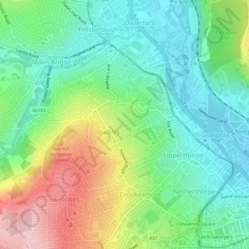
Name: Walkley topographic map, elevation, terrain.
Average elevation: 118 m
Minimum elevation: 50 m
Maximum elevation: 248 m
Thank you for supporting this site ❤️
Make a donation
Make a donation
Other topographic maps
Click on a map to view its topography, its elevation and its terrain.
Thank you for supporting this site ❤️
Make a donation
Make a donation
Wharncliffe Side
United Kingdom > England > Sheffield
Wharcliffe Side is located on the west bank of the River Don, approximately six miles (9.7 km) northwest of Sheffield city centre, and one mile (1.6 km) northwest of Oughtibridge, south of the confluence of the Ewden beck and the River Don. The village is at an elevation of 435 feet (133 m) and the A6102 road…
Average elevation: 219 m
Thank you for supporting this site ❤️
Make a donation
Make a donation
Thank you for supporting this site ❤️
Make a donation
Make a donation
Thank you for supporting this site ❤️
Make a donation
Make a donation
Thank you for supporting this site ❤️
Make a donation
Make a donation
Thank you for supporting this site ❤️
Make a donation
Make a donation
Thank you for supporting this site ❤️
Make a donation
Make a donation
Thank you for supporting this site ❤️
Make a donation
Make a donation
Thank you for supporting this site ❤️
Make a donation
Make a donation
Thank you for supporting this site ❤️
Make a donation
Make a donation
Thank you for supporting this site ❤️
Make a donation
Make a donation
Thank you for supporting this site ❤️
Make a donation
Make a donation
Thank you for supporting this site ❤️
Make a donation
Make a donation
