
Make a donation
Arraba topographic map
Click on the map to display elevation.
Make a donation
About this map
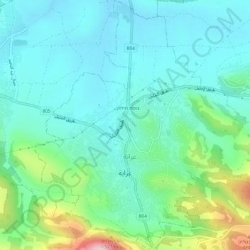
Name: Arraba topographic map, elevation, terrain.
Location: Arraba, Acre Subdistrict, North District, Israel (32.83687 35.31939 32.87488 35.36183)
Average elevation: 245 m
Minimum elevation: 172 m
Maximum elevation: 501 m
Make a donation
Other topographic maps
Click on a map to view its topography, its elevation and its terrain.
2236 Mt. Hermon
Israel > North District > Golan Regional Council
Mount Hermon (Arabic: جبل الشيخ or جبل حرمون / ALA-LC: Jabal al-Shaykh ('Mountain of the Sheikh') or Jabal Haramun; Hebrew: הַר חֶרְמוֹן, Har Ḥermōn) is a mountain cluster constituting the southern end of the Anti-Lebanon mountain range. Its summit straddles the border between…
Average elevation: 2,016 m
Make a donation
Make a donation
Make a donation
Make a donation
Make a donation
Nazareth
Israel > North District > Nazareth
As of the early 1990s, no city plans drafted by Nazareth Municipality have been approved by the government (both the British Mandate and later Israel) since 1942. This has left many people in Nazareth who vote in the city's municipal elections and receive services from its municipality effectively outside of…
Average elevation: 151 m
Make a donation
Tiberias
Tiberias is located on the shore of the Sea of Galilee and the western slopes of the Jordan Rift Valley overlooking the lake, in the elevation range of −200 to 200 metres (−660–660 feet). Tiberias has a climate that borders a Hot-summer Mediterranean climate (koppen Csa) and a Hot Semi-arid climate…
Average elevation: -2 m
Karmiel
Karmiel is located on the Acre–Safed road, on the northern edge of the Lower Galilee. It lies in the Beit HaKerem Valley and its elevation is 330 m (1,082.68 ft). The Hilazon Stream passes slightly to the south of Karmiel. Its tributaries, the Shezor and Shagor Streams pass through Karmiel on the east and…
Average elevation: 241 m
Make a donation
Deganya Alef
Israel > North District > Emek HaYarden Regional Council > Deganya Alef
Average elevation: -201 m
Make a donation
Make a donation