
Make a donation
Tiberias topographic map
Click on the map to display elevation.
Make a donation
Tiberias
Tiberias is located on the shore of the Sea of Galilee and the western slopes of the Jordan Rift Valley overlooking the lake, in the elevation range of −200 to 200 metres (−660–660 feet). Tiberias has a climate that borders a Hot-summer Mediterranean climate (koppen Csa) and a Hot Semi-arid climate (koppen BSh), with an annual precipitation of about 400 mm (15.75 in). Summers in Tiberias average a maximum temperature of 36 °C (97 °F) and a minimum temperature of 21 °C (70 °F) in July and August. The winters are mild, with temperatures ranging from 8 to 18 °C (46–64 °F). Extremes have ranged from 0 °C (32 °F) to 46 °C (115 °F).
Make a donation
About this map
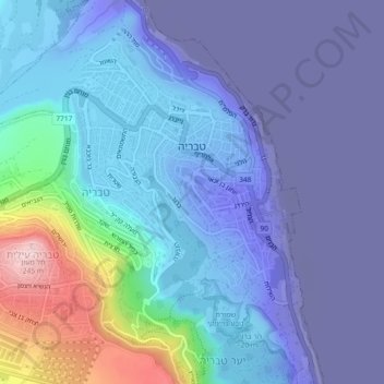
Name: Tiberias topographic map, elevation, terrain.
Location: Tiberias, Kinneret Subdistrict, North District, Israel (32.77400 35.49869 32.80449 35.54449)
Average elevation: -2 m
Minimum elevation: -218 m
Maximum elevation: 249 m
Make a donation
Other topographic maps
Click on a map to view its topography, its elevation and its terrain.
Sea of Galilee
After five years of drought as of 2018, Sea of Galilee is expected to get to the black line. The black elevation line is the lowest depth from which irreversible damage begins and no water can be pumped out any more. Israel Oceanographic and Limnological Research describes it as "The black line marks −214.87…
Average elevation: -67 m
2236 Mt. Hermon
Israel > North District > Golan Regional Council
Mount Hermon (Arabic: جبل الشيخ or جبل حرمون / ALA-LC: Jabal al-Shaykh ('Mountain of the Sheikh') or Jabal Haramun; Hebrew: הַר חֶרְמוֹן, Har Ḥermōn) is a mountain cluster constituting the southern end of the Anti-Lebanon mountain range. Its summit straddles the border between…
Average elevation: 2,016 m
Golan Heights
The Golan Heights is a basaltic plateau in southwestern Syria, extending about 44 miles (71 km) from north to south and about 27 miles (43 km) from east to west at its widest point, covering approximately 444 square miles (1,150 square km). The terrain is characterized by its hilly and elevated nature, with an…
Average elevation: 524 m
Make a donation
Nazareth
As of the early 1990s, no city plans drafted by Nazareth Municipality have been approved by the government (both the British Mandate and later Israel) since 1942. This has left many people in Nazareth who vote in the city's municipal elections and receive services from its municipality effectively outside of…
Average elevation: 358 m
Make a donation
Majdal Shams
The name "Majdal Shams" originates from Aramaic, meaning: "tower of sun" in reference (possibly) to the town's elevation. Another hypothesis suggests that the town was originally called Majdal al-Sham (Majdal of Damascus) to distinguish it from the towns of al-Majdal on the Mediterranean Coast and al-Majdal on…
Average elevation: 1,232 m
Make a donation
Make a donation
Nazareth
Israel > North District > Nazareth
As of the early 1990s, no city plans drafted by Nazareth Municipality have been approved by the government (both the British Mandate and later Israel) since 1942. This has left many people in Nazareth who vote in the city's municipal elections and receive services from its municipality effectively outside of…
Average elevation: 151 m
Make a donation
Make a donation
Make a donation