
Ballard County topographic map
Interactive map
Click on the map to display elevation.
About this map
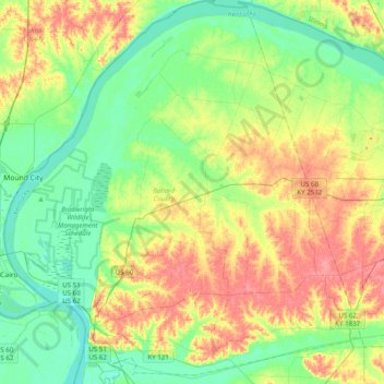
Name: Ballard County topographic map, elevation, terrain.
Location: Ballard County, Kentucky, USA (36.91546 -89.18251 37.22989 -88.81583)
Average elevation: 113 m
Minimum elevation: 87 m
Maximum elevation: 153 m
Other topographic maps
Click on a map to view its topography, its elevation and its terrain.
Madisonville
USA > Kentucky > Madisonville
Madisonville, Hopkins County, Kentucky, 42431, USA
Average elevation: 136 m
Bowling Green
USA > Kentucky > Bowling Green
Bowling Green, Warren County, Kentucky, 42101, USA
Average elevation: 169 m
Georgetown
USA > Kentucky > Georgetown
Georgetown, Scott County, Kentucky, 40324, USA
Average elevation: 265 m
Mammoth Cave
USA > Kentucky > Mammoth Cave
Mammoth Cave, Edmonson County, Kentucky, USA
Average elevation: 214 m