
Brunei-Muara District topographic map
Interactive map
Click on the map to display elevation.
About this map
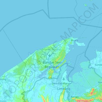
Name: Brunei-Muara District topographic map, elevation, terrain.
Location: Brunei-Muara District, Brunei (4.73050 114.66109 5.19913 115.23844)
Average elevation: 9 m
Minimum elevation: -4 m
Maximum elevation: 404 m
Other topographic maps
Click on a map to view its topography, its elevation and its terrain.
Kampong Lumut
Kampong Lumut, Mukim Liang, Belait District, Brunei
Average elevation: 9 m