
Make a donation
Venado Tuerto topographic map
Click on the map to display elevation.
Make a donation
About this map
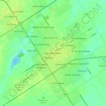
Name: Venado Tuerto topographic map, elevation, terrain.
Average elevation: 113 m
Minimum elevation: 105 m
Maximum elevation: 119 m
Make a donation
Other topographic maps
Click on a map to view its topography, its elevation and its terrain.
Catamarca
The province is located in the semi–arid region of Argentina. Mean annual precipitation of the province is around 400 to 500 mm (16 to 20 in) which decreases significantly to the west. The province is characterized by the presence of different microclimates based on variations in altitude. In general, there…
Average elevation: 2,292 m
Make a donation
Patagonia
Across much of Patagonia east of the Andes, volcanic eruptions have created formation of basaltic lava plateaus during the Cenozoic. The plateaus are of different ages with the older –of Neogene and Paleogene age– being located at higher elevations than Pleistocene and Holocene lava plateaus and outcrops.
Average elevation: 173 m
Ushuaia
Several ski areas are located near Ushuaia, including Glacier El Martial (on Martial Mountains) and Cerro Castor. Opened in 1999, Cerro Castor is the southernmost full-fledged ski resort in the world. On Cerro Castor, it is possible to ski just 200 metres (660 feet) above sea level. The summit reaches an…
Average elevation: 267 m
Make a donation
Ushuaia
Argentina > Tierra del Fuego Province > Ushuaia
Several ski areas are located near Ushuaia including Glacier El Martial (on Martial Mountains) and Cerro Castor. Opened in 1999, Cerro Castor is the southernmost full-fledged ski resort in the world. On Cerro Castor, it is possible to ski just 200 metres (660 feet) above sea level. The summit reaches an…
Average elevation: 232 m
Distrito Ciudad de Tupungato
Argentina > Mendoza > Distrito Ciudad de Tupungato
Average elevation: 1,078 m
Cordoba
Argentina > Córdoba > Pedanía Capital
The wealthier suburbs west of the city are located at slightly higher altitudes, which allows cool breezes to blow in the summer, bringing drier, comfortable nights during hotter periods, and more regular frost in the winter. Generally speaking, Córdoba's daytime temperatures are very slightly warmer than…
Average elevation: 439 m
Make a donation
Make a donation
Salta
Salta has a subtropical highland climate (Cwb, according to the Köppen climate classification), and it is characterized by pleasant weather year-round. Located in the subtropical north, but at an altitude of 1,200 metres, Salta enjoys 4 distinct seasons: summers are warm with frequent thunderstorms, with…
Average elevation: 1,270 m
Make a donation
Make a donation
Make a donation
San Carlos de Bariloche
Bariloche lies in the transition between a cool Mediterranean climate (Köppen Csb) and an Oceanic climate (Köppen: Cfb), with marked alpine characteristics (low nighttime temperatures, wide temperature variations, high thermal amplitude). The combination of its altitude, latitude, and predominance of…
Average elevation: 1,042 m
Neuquén
Mean temperatures are relatively cold for its latitude due to the high altitude. The warmest region is the eastern parts of the province where mean annual temperatures range from 13 to 15 °C (55.4 to 59.0 °F). The coldest areas are located in the Andean region where mean annual temperatures are below 5 °C…
Average elevation: 809 m
Make a donation
Mendoza
Argentina > Mendoza > Sección 2ª Barrio Cívico
Argentina's Malbec wines originate from Mendoza's high-altitude wine regions of Lujan de Cuyo and the Uco Valley. These districts are located in the foothills of the Andes mountains between 2,800 and 5,000 feet elevation. Vintner Nicolas Catena Zapata is considered the pioneer of high-altitude growing and was…
Average elevation: 890 m
Calingasta
Calingasta has a rugged, mountainous topography due to its location at the foot of the Andes. Mount Mercedario is the eighth-highest mountain of the Andes with an altitude of 6,720 metres (22,050 ft). It is located 100 kilometres (62 mi) north of Aconcagua. The precordillera range is the Sierra del Tontal,…
Average elevation: 2,393 m
Make a donation
Córdoba
Córdoba, located just north of the geographical center of the nation, is Argentina's fifth-largest province. The main feature of the province is the presence of an extensive plain covering the eastern two-thirds of the province and the existence of three major mountain ranges, which, combined, are known as…
Average elevation: 324 m
Make a donation
Cordoba
Argentina > Córdoba > Pedanía Capital
The wealthier suburbs west of the city are located at slightly higher altitudes, which allows cool breezes to blow in the summer, bringing drier, comfortable nights during hotter periods, and more regular frost in the winter. Generally speaking, Córdoba's daytime temperatures are very slightly warmer than…
Average elevation: 439 m
Make a donation
Santa Rosa
The town occupies part of a centripetal basin having their base in Don Tomás Lagoon, where rainwater drains from the surrounding area. The floor area lies west of it, in hilly terrain where the highest elevations are in the east, with two small plateaus located 200 meters. This high turnover is also observed…
Average elevation: 185 m
Make a donation
Make a donation
Make a donation
Ushuaia
Argentina > Tierra del Fuego Province
Several ski areas are located near Ushuaia, including Glacier El Martial (on Martial Mountains) and Cerro Castor. Opened in 1999, Cerro Castor is the southernmost full-fledged ski resort in the world. On Cerro Castor, it is possible to ski just 200 metres (660 feet) above sea level. The summit reaches an…
Average elevation: 267 m
Mendoza
The area around Malargue is located at higher elevation (1400 meters) and thus the weather is significantly colder: summers average 28 °C (82 °F) during the day, but only 11 °C (53F) at night, and winters range from 10 °C (50 °F) to −2 °C (28 °F). Here, precipitation is somewhat higher (350 mm) and…
Average elevation: 1,069 m
Make a donation
Mendoza
The area around Malargue is located at higher elevation (1400 meters) and thus the weather is significantly colder: summers average 28 °C (82 °F) during the day, but only 11 °C (53F) at night, and winters range from 10 °C (50 °F) to −2 °C (28 °F). Here, precipitation is somewhat higher (350 mm) and…
Average elevation: 1,055 m
Municipio de San Salvador de Jujuy
Jujuy has a humid subtropical climate (Cwa, according to the Köppen climate classification), mainly because of the altitude. Summers bring warm days at 28 °C (82 °F) and nights at 16 °C (61 °F) with frequent thunderstorms. The rest of the year is sunny, with temperatures at about 24 °C (75 °F) during…
Average elevation: 1,913 m
Rosario
The airport serves the Greater Rosario area and is the main hub for Sol Líneas Aéreas and is also served by Aerolíneas Argentinas, Copa and Gol Transportes Aéreos. There are domestic flights within Argentina from Rosario to Buenos Aires, Córdoba, Mar del Plata (via Buenos Aires), Mendoza (vía Córdoba),…
Average elevation: 20 m
Make a donation
El Calafate
Argentina > Santa Cruz Province
The most recent World Altitude Gliding record of 22,657 m (74,333 ft) was set near El Calafate on 2 September 2018 by Jim Payne and Tim Gardner in the new Perlan 2 glider (with pressurised cabin).
Average elevation: 432 m
Neuquén
Mean temperatures are relatively cold for its latitude due to the high altitude. The warmest region is the eastern parts of the province where mean annual temperatures range from 13 to 15 °C (55.4 to 59.0 °F). The coldest areas are located in the Andean region where mean annual temperatures are below 5 °C…
Average elevation: 809 m
Make a donation
Make a donation
San Carlos de Bariloche
Bariloche lies in the transition between a cool Mediterranean climate (Köppen Csb) and an Oceanic climate (Köppen: Cfb), with marked alpine characteristics (low nighttime temperatures, wide temperature variations, high thermal amplitude). The combination of its altitude, latitude, and predominance of…
Average elevation: 1,042 m
Make a donation
Sierra de los Padres
Sierra de los Padres is a string of rocky hills and ridges about 14 miles west of Mar del Plata. They are part of Tandilia's mountain range, actually a series of low rock-strewn elevations of precambrian origin extended from central Buenos Aires Province to Cabo Corrientes, a cape on the shores of Mar del…
Average elevation: 97 m
Make a donation
Tucumán
Despite Tucumán's small size, it has two main different geographical systems. The east is associated with the Gran Chaco flat lands, while the west presents a mixture of the Sierras of the Pampas to the south and the canyons of the Argentine Northwest to the north. The Cerro del Bolsón is the highest peak at…
Average elevation: 1,226 m
Make a donation
Rosario
The airport serves the Greater Rosario area and is the main hub for Sol Líneas Aéreas and is also served by Aerolíneas Argentinas, Copa and Gol Transportes Aéreos. There are domestic flights within Argentina from Rosario to Buenos Aires, Córdoba, Mar del Plata (via Buenos Aires), Mendoza (vía Córdoba),…
Average elevation: 20 m
Make a donation
Staten Island
Argentina > Tierra del Fuego Province
Temperatures are low year round but without extreme minimum temperatures. The mean temperature in summer is 8.3 °C (46.9 °F) with mean extremes of 16.2 °C (61.2 °F) and 3.0 °C (37.4 °F) while in winter, the mean temperature is 3.3 °C (37.9 °F) with mean extremes of 7.7 °C (45.9 °F) and −4 °C (24.8…
Average elevation: 23 m
Make a donation
Rosario
The airport serves the Greater Rosario area and is the main hub for Sol Líneas Aéreas and is also served by Aerolíneas Argentinas, Copa and Gol Transportes Aéreos. There are domestic flights within Argentina from Rosario to Buenos Aires, Córdoba, Mar del Plata (via Buenos Aires), Mendoza (vía Córdoba),…
Average elevation: 20 m
Make a donation
Make a donation