
Champlan topographic map
Interactive map
Click on the map to display elevation.
About this map
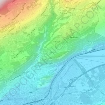
Name: Champlan topographic map, elevation, terrain.
Location: Champlan, Grimisuat, Sion, Valais, 1971, Suisse (46.22630 7.35092 46.26630 7.39092)
Average elevation: 696 m
Minimum elevation: 482 m
Maximum elevation: 1,345 m
Other topographic maps
Click on a map to view its topography, its elevation and its terrain.
Les Fermes
Suisse > Valais > Sion > Grimisuat
Les Fermes, Grimisuat, Sion, Valais, 1971, Suisse
Average elevation: 720 m