
Les Fermes topographic map
Interactive map
Click on the map to display elevation.
About this map
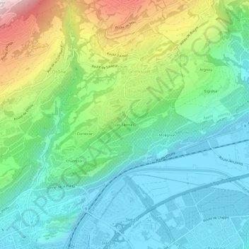
Name: Les Fermes topographic map, elevation, terrain.
Location: Les Fermes, Grimisuat, Sion, Valais, 1971, Suisse (46.23205 7.36248 46.27205 7.40248)
Average elevation: 720 m
Minimum elevation: 488 m
Maximum elevation: 1,314 m
Other topographic maps
Click on a map to view its topography, its elevation and its terrain.