
Make a donation
Khyber Pakhtunkhwa topographic map
Click on the map to display elevation.
Make a donation
Khyber Pakhtunkhwa
Most precipitation falls as thunderstorms or snow during winter and spring, so that the climate at the lowest elevations is classed as Mediterranean (Csa), continental Mediterranean (Dsa) or semi-arid (BSk). Summers are extremely dry in the north of Chitral district and receive only a little rain in the south around Drosh.
Make a donation
About this map
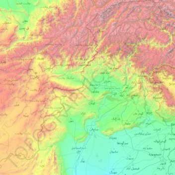
Name: Khyber Pakhtunkhwa topographic map, elevation, terrain.
Location: Khyber Pakhtunkhwa, Pakistan (31.06680 69.23780 36.90879 74.11646)
Average elevation: 1,902 m
Minimum elevation: 146 m
Maximum elevation: 7,597 m
Make a donation
Other topographic maps
Click on a map to view its topography, its elevation and its terrain.
Mithi
Pakistan > Sindh > Tharparkar District
The town is located at 24°74'0N 69°80'0E with an altitude of 28 meters (92 feet). It lies 450 kilometers from Karachi and is located in a desert area. The geography of Mithi is characterized by its arid landscape, typical of the Thar Desert, which influences the climate, agriculture, and daily life in the…
Average elevation: 56 m
Make a donation